Colțești geodata
Colțești (Alba) is a populated place; located in Romania in Europe/Bucharest (GMT+3) time zone. With population of 753 people, there are 5270 cities with bigger population in this country. Compared to other cities in Romania, 65.2% of cities are located further ↓South; 76.1% of cities are located further →East and 92.9% of cities have lower elevation than Colțești. Note1


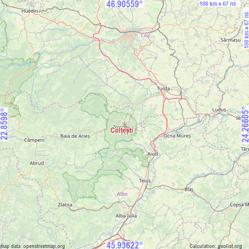
Colțești GPS coordinates[2]
46° 25' 23.016" North, 23° 33' 46.512" East
| Map corner | latitude | longitude |
|---|---|---|
| Upper-left | 46.90559°, | 22.8598° |
| Center: | 46.42306°, | 23.56292° |
| Lower-right: | 45.93622°, | 24.26605° |
| Map W x H: | 107.8×107.8 km | = 67×67mi |
| max Lat: | 48.23793° ⇑34.8% North |
| Colțești: | 46.42306° |
| min Lat: | ⇓65.2% South 43.65638° |
| min Long | Colțești | max Long |
| 20.31667° | 23.56292° | 29.65403° |
| W 23.9%⇐ | ⇒76.1% E |
Elevation
Elevation of Colțești is 567 m = 1860 ft, and this is 312.1 m = 1024 ft above average elevation for this country.
| Max E: |
1278 m = 4193 ft | 7.1% |
| Colțești | 567 m 1860 ft | |
| Avg. | 254.9 m = 836 ft | |
Min E: |
-2 m = -7 ft | 92.9% |
See also: Romania elevation on elevation.city.
Geographical zone
Colțești is located in North temperate zone (between Tropic of Cancer and the Arctic Circle). Distance of this North polar circle is 2239.4 km =1391.5 mi to North.| Distance of | km | miles | from Colțești |
|---|---|---|---|
| North Pole | 4845.3 | 3010.7 | to North |
| Arctic Circle | 2239.4 | 1391.5 | to North |
| Tropic Cancer | 2555.8 | 1588.1 | to South |
| Equator | 5161.8 | 3207.4 | to South |


Nearby cities:
15 places around Colțești: (largest is in red/bold)
• Brusturei
13.9 km =8.6 mi,  189°
189°
• Iara
14.6 km =9.1 mi,  345°
345°
• Livezile
9.8 km =6.1 mi,  146°
146°
• Mirăslău
13.4 km =8.3 mi,  118°
118°
• Moldoveneşti
10.8 km =6.7 mi,  37°
37°
• Măgina
11.4 km =7.1 mi,  143°
143°
• Ocoliş
10 km =6.2 mi,  312°
312°
• Plăiești
14.1 km =8.8 mi,  54°
54°
• Podeni
6.1 km =3.8 mi,  85°
85°
• Poiana Aiudului
7.3 km =4.5 mi, 152°
• Poşaga de Sus
14.6 km =9.1 mi,  289°
289°
• Poșaga de Jos
9.4 km =5.8 mi,  275°
275°
• Rimetea
3 km =1.9 mi,  5°
5°
• Sălciua de Jos
11.2 km =7 mi,  255°
255°
• Sălciua de Sus
11.5 km =7.1 mi, 257°
Sources, notices
• [Note1] Compared only with cities in Romania existing in our database
• [Src1] Map data: © OpenStreetMap contributors (CC-BY-SA)
• [Src2] Other city data from geonames.org with taken over terms of usage.
• [Src3] Geographical zone / Annual Mean Temperature by Robert A. Rohde @ Wikipedia
