Ocoliş geodata
Ocoliş (Alba) is a seat of a second-order administrative division; located in Romania in Europe/Bucharest (GMT+3) time zone. With population of 832 people, there are 4912 cities with bigger population in this country. Compared to other cities in Romania, 66.7% of cities are located further ↓South; 77.6% of cities are located further →East and 89.2% of cities have lower elevation than Ocoliş. Note1


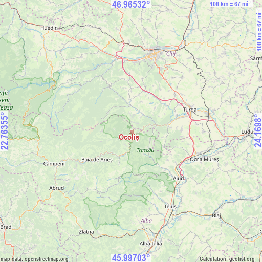
Ocoliş GPS coordinates[2]
46° 28' 59.988" North, 23° 28' 0.012" East
| Map corner | latitude | longitude |
|---|---|---|
| Upper-left | 46.96532°, | 22.76355° |
| Center: | 46.48333°, | 23.46667° |
| Lower-right: | 45.99703°, | 24.1698° |
| Map W x H: | 107.7×107.7 km | = 66.9×66.9mi |
| max Lat: | 48.23793° ⇑33.3% North |
| Ocoliş: | 46.48333° |
| min Lat: | ⇓66.7% South 43.65638° |
| min Long | Ocoliş | max Long |
| 20.31667° | 23.46667° | 29.65403° |
| W 22.4%⇐ | ⇒77.6% E |
Elevation
Elevation of Ocoliş is 500 m = 1640 ft, and this is 245.1 m = 804 ft above average elevation for this country.
| Max E: |
1278 m = 4193 ft | 10.8% |
| Ocoliş | 500 m 1640 ft | |
| Avg. | 254.9 m = 836 ft | |
Min E: |
-2 m = -7 ft | 89.2% |
See also: Romania elevation on elevation.city.
Geographical zone
Ocoliş is located in North temperate zone (between Tropic of Cancer and the Arctic Circle). Distance of this North polar circle is 2232.7 km =1387.3 mi to North.| Distance of | km | miles | from Ocoliş |
|---|---|---|---|
| North Pole | 4838.6 | 3006.6 | to North |
| Arctic Circle | 2232.7 | 1387.3 | to North |
| Tropic Cancer | 2562.5 | 1592.3 | to South |
| Equator | 5168.5 | 3211.6 | to South |


Nearby cities:
15 places around Ocoliş: (largest is in red/bold)
• Agriș
12.9 km =8 mi,  18°
18°
• Băişoara
11.1 km =6.9 mi,  0°
0°
• Cacova Ierii
6.7 km =4.2 mi,  5°
5°
• Colțești
10 km =6.2 mi,  132°
132°
• Cornești
17.7 km =11 mi,  75°
75°
• Iara
8.3 km =5.2 mi,  27°
27°
• Moldoveneşti
14.2 km =8.8 mi, 82°
• Podeni
14.8 km =9.2 mi,  114°
114°
• Poiana Aiudului
16.9 km =10.5 mi,  140°
140°
• Ponor
17.1 km =10.6 mi,  192°
192°
• Poşaga de Sus
6.6 km =4.1 mi,  253°
253°
• Poșaga de Jos
6.2 km =3.9 mi,  199°
199°
• Rimetea
8.5 km =5.3 mi,  115°
115°
• Sălciua de Jos
10 km =6.2 mi, 200°
• Sălciua de Sus
10 km =6.2 mi, 202°
Sources, notices
• [Note1] Compared only with cities in Romania existing in our database
• [Src1] Map data: © OpenStreetMap contributors (CC-BY-SA)
• [Src2] Other city data from geonames.org with taken over terms of usage.
• [Src3] Geographical zone / Annual Mean Temperature by Robert A. Rohde @ Wikipedia
