Iara geodata
Iara (Cluj) is a seat of a second-order administrative division; located in Romania in Europe/Bucharest (GMT+3) time zone. With population of 4,660 people, there are 896 cities with bigger population in this country. Compared to other cities in Romania, 68.1% of cities are located further ↓South; 76.8% of cities are located further →East and 85.7% of cities have lower elevation than Iara. Note1


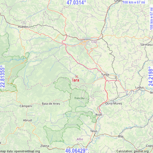
Iara GPS coordinates[2]
46° 33' 0" North, 23° 31' 0.012" East
| Map corner | latitude | longitude |
|---|---|---|
| Upper-left | 47.0314°, | 22.81355° |
| Center: | 46.55°, | 23.51667° |
| Lower-right: | 46.06429°, | 24.2198° |
| Map W x H: | 107.5×107.5 km | = 66.8×66.8mi |
| max Lat: | 48.23793° ⇑31.9% North |
| Iara: | 46.55° |
| min Lat: | ⇓68.1% South 43.65638° |
| min Long | Iara | max Long |
| 20.31667° | 23.51667° | 29.65403° |
| W 23.2%⇐ | ⇒76.8% E |
Elevation
Elevation of Iara is 454 m = 1490 ft, and this is 199.1 m = 653 ft above average elevation for this country.
| Max E: |
1278 m = 4193 ft | 14.3% |
| Iara | 454 m 1490 ft | |
| Avg. | 254.9 m = 836 ft | |
Min E: |
-2 m = -7 ft | 85.7% |
See also: Romania elevation on elevation.city.
Geographical zone
Iara is located in North temperate zone (between Tropic of Cancer and the Arctic Circle). Distance of this North polar circle is 2225.3 km =1382.7 mi to North.| Distance of | km | miles | from Iara |
|---|---|---|---|
| North Pole | 4831.2 | 3002 | to North |
| Arctic Circle | 2225.3 | 1382.7 | to North |
| Tropic Cancer | 2570 | 1596.9 | to South |
| Equator | 5175.9 | 3216.2 | to South |


Nearby cities:
15 places around Iara: (largest is in red/bold)
• Agriș
4.9 km =3 mi,  3°
3°
• Băişoara
5.3 km =3.3 mi,  314°
314°
• Cacova Ierii
3.3 km =2.1 mi,  257°
257°
• Cheia
14.7 km =9.1 mi,  93°
93°
• Ciurila
11.4 km =7.1 mi,  12°
12°
• Colțești
14.6 km =9.1 mi,  165°
165°
• Cornești
13.6 km =8.5 mi,  102°
102°
• Hășdate
12.4 km =7.7 mi,  327°
327°
• Micești
12.9 km =8 mi,  36°
36°
• Moldoveneşti
11.6 km =7.2 mi,  118°
118°
• Ocoliş
8.3 km =5.2 mi,  207°
207°
• Petreştii de Jos
10.8 km =6.7 mi,  70°
70°
• Poşaga de Sus
13.8 km =8.6 mi,  227°
227°
• Poșaga de Jos
14.5 km =9 mi,  203°
203°
• Rimetea
11.8 km =7.3 mi,  161°
161°
Sources, notices
• [Note1] Compared only with cities in Romania existing in our database
• [Src1] Map data: © OpenStreetMap contributors (CC-BY-SA)
• [Src2] Other city data from geonames.org with taken over terms of usage.
• [Src3] Geographical zone / Annual Mean Temperature by Robert A. Rohde @ Wikipedia
