Nuntași geodata
Nuntași (Constanța) is a populated place; located in Romania in Europe/Bucharest (GMT+3) time zone. With population of 1,144 people, there are 3870 cities with bigger population in this country. Compared to other cities in Romania, 84.4% of cities are located further ↑North; 99.3% of cities are located further ←West and 98.7% of cities have higher elevation than Nuntași. Note1


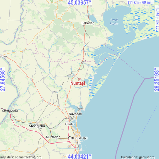
Nuntași GPS coordinates[2]
44° 32' 15.18" North, 28° 38' 55.68" East
| Map corner | latitude | longitude |
|---|---|---|
| Upper-left | 45.03657°, | 27.94568° |
| Center: | 44.53755°, | 28.6488° |
| Lower-right: | 44.03421°, | 29.35193° |
| Map W x H: | 111.5×111.5 km | = 69.3×69.3mi |
| max Lat: | 48.23793° ⇑84.4% North |
| Nuntași: | 44.53755° |
| min Lat: | ⇓15.6% South 43.65638° |
| min Long | Nuntași | max Long |
| 20.31667° | 28.6488° | 29.65403° |
| W 99.3%⇐ | ⇒0.7% E |
Elevation
Elevation of Nuntași is 13 m = 43 ft, and this is 241.9 m = 794 ft below average elevation for this country.
| Max E: |
1278 m = 4193 ft | 98.7% |
| Avg. | 254.9 m = 836 ft | |
| Nuntași | 13 m = 43 ft | |
Min E: |
-2 m = -7 ft | 1.3% |
See also: Romania elevation on elevation.city.
Geographical zone
Nuntași is located in North temperate zone (between Tropic of Cancer and the Arctic Circle). Distance of this Northern Tropic circle is 2346.2 km =1457.9 mi to South.| Distance of | km | miles | from Nuntași |
|---|---|---|---|
| North Pole | 5055 | 3141 | to North |
| Arctic Circle | 2449.1 | 1521.8 | to North |
| Tropic Cancer | 2346.2 | 1457.9 | to South |
| Equator | 4952.1 | 3077.1 | to South |


Nearby cities:
15 places around Nuntași: (largest is in red/bold)
• Baia
20 km =12.4 mi,  4°
4°
• Beidaud
20.9 km =13 mi,  341°
341°
• Cogealac
6.7 km =4.2 mi,  282°
282°
• Corbu
17.1 km =10.6 mi,  179°
179°
• Fântânele
10.1 km =6.3 mi,  325°
325°
• Grădina
17.3 km =10.7 mi, 276°
• Istria
6.3 km =3.9 mi,  58°
58°
• Mihai Viteazu
11 km =6.8 mi,  14°
14°
• Piatra
16.3 km =10.1 mi,  205°
205°
• Râmnicu de Jos
18.4 km =11.4 mi,  303°
303°
• Sarighiol de Deal
20.9 km =13 mi, 329°
• Săcele
6 km =3.7 mi, 179°
• Tariverde
4.6 km =2.9 mi,  307°
307°
• Târguşor
20.8 km =12.9 mi,  242°
242°
• Vadu
11.8 km =7.3 mi,  144°
144°
Sources, notices
• [Note1] Compared only with cities in Romania existing in our database
• [Src1] Map data: © OpenStreetMap contributors (CC-BY-SA)
• [Src2] Other city data from geonames.org with taken over terms of usage.
• [Src3] Geographical zone / Annual Mean Temperature by Robert A. Rohde @ Wikipedia
