Ciorogârla geodata
Ciorogârla (Ilfov) is a seat of a second-order administrative division; located in Romania in Europe/Bucharest (GMT+3) time zone. With population of 4,968 people, there are 795 cities with bigger population in this country. Compared to other cities in Romania, 87% of cities are located further ↑North; 60.8% of cities are located further ←West and 79.6% of cities have higher elevation than Ciorogârla. Note1


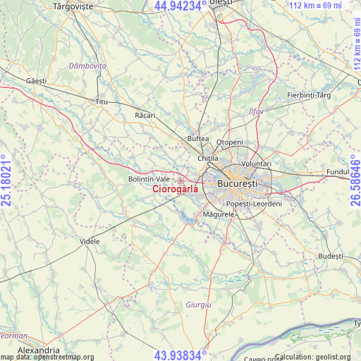
Ciorogârla GPS coordinates[2]
44° 26' 33" North, 25° 52' 59.988" East
| Map corner | latitude | longitude |
|---|---|---|
| Upper-left | 44.94234°, | 25.18021° |
| Center: | 44.4425°, | 25.88333° |
| Lower-right: | 43.93834°, | 26.58646° |
| Map W x H: | 111.6×111.6 km | = 69.3×69.3mi |
| max Lat: | 48.23793° ⇑87% North |
| Ciorogârla: | 44.4425° |
| min Lat: | ⇓13% South 43.65638° |
| min Long | Ciorogârla | max Long |
| 20.31667° | 25.88333° | 29.65403° |
| W 60.8%⇐ | ⇒39.2% E |
Elevation
Elevation of Ciorogârla is 96 m = 315 ft, and this is 158.9 m = 521 ft below average elevation for this country.
| Max E: |
1278 m = 4193 ft | 79.6% |
| Avg. | 254.9 m = 836 ft | |
| Ciorogârla | 96 m = 315 ft | |
Min E: |
-2 m = -7 ft | 20.4% |
See also: Romania elevation on elevation.city.
Geographical zone
Ciorogârla is located in North temperate zone (between Tropic of Cancer and the Arctic Circle). Distance of this Northern Tropic circle is 2335.6 km =1451.3 mi to South.| Distance of | km | miles | from Ciorogârla |
|---|---|---|---|
| North Pole | 5065.5 | 3147.6 | to North |
| Arctic Circle | 2459.6 | 1528.3 | to North |
| Tropic Cancer | 2335.6 | 1451.3 | to South |
| Equator | 4941.5 | 3070.5 | to South |


Nearby cities:
15 places around Ciorogârla: (largest is in red/bold)
• Bolintin Deal
5.3 km =3.3 mi,  290°
290°
• Bâcu
4.5 km =2.8 mi,  5°
5°
• Chiajna
7.4 km =4.6 mi,  74°
74°
• Domneşti-Sârbi
7.1 km =4.4 mi,  158°
158°
• Domnești
5.5 km =3.4 mi,  151°
151°
• Dragomireşti-Vale
5.5 km =3.4 mi,  48°
48°
• Dragomirești-Deal
5.4 km =3.4 mi, 65°
• Dârvari
2.4 km =1.5 mi,  186°
186°
• Joiţa
6.2 km =3.9 mi,  337°
337°
• Mihai Vodă
5.1 km =3.2 mi,  265°
265°
• Olteni
7.6 km =4.7 mi,  135°
135°
• Săbăreni
6.6 km =4.1 mi,  3°
3°
• Tântava
5.6 km =3.5 mi,  236°
236°
• Zurbaua
5.8 km =3.6 mi,  24°
24°
• Țegheș
6.8 km =4.2 mi, 186°
Sources, notices
• [Note1] Compared only with cities in Romania existing in our database
• [Src1] Map data: © OpenStreetMap contributors (CC-BY-SA)
• [Src2] Other city data from geonames.org with taken over terms of usage.
• [Src3] Geographical zone / Annual Mean Temperature by Robert A. Rohde @ Wikipedia
