Olteni geodata
Olteni (Ilfov) is a populated place; located in Romania in Europe/Bucharest (GMT+3) time zone. With population of 1,022 people, there are 4215 cities with bigger population in this country. Compared to other cities in Romania, 88.3% of cities are located further ↑North; 62% of cities are located further ←West and 83.1% of cities have higher elevation than Olteni. Note1


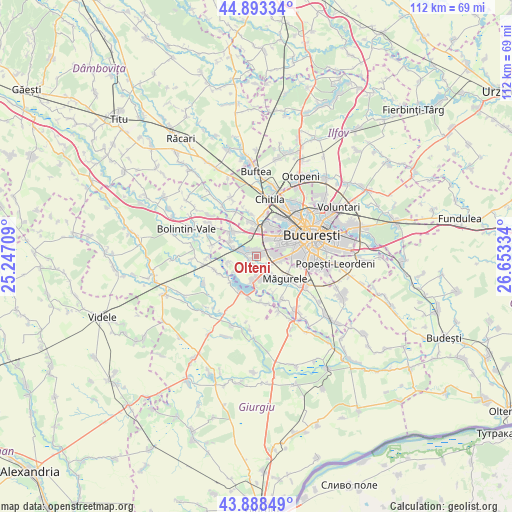
Olteni GPS coordinates[2]
44° 23' 35.052" North, 25° 57' 0.756" East
| Map corner | latitude | longitude |
|---|---|---|
| Upper-left | 44.89334°, | 25.24709° |
| Center: | 44.39307°, | 25.95021° |
| Lower-right: | 43.88849°, | 26.65334° |
| Map W x H: | 111.7×111.7 km | = 69.4×69.4mi |
| max Lat: | 48.23793° ⇑88.3% North |
| Olteni: | 44.39307° |
| min Lat: | ⇓11.7% South 43.65638° |
| min Long | Olteni | max Long |
| 20.31667° | 25.95021° | 29.65403° |
| W 62%⇐ | ⇒38% E |
Elevation
Elevation of Olteni is 84 m = 276 ft, and this is 170.9 m = 561 ft below average elevation for this country.
| Max E: |
1278 m = 4193 ft | 83.1% |
| Avg. | 254.9 m = 836 ft | |
| Olteni | 84 m = 276 ft | |
Min E: |
-2 m = -7 ft | 16.9% |
See also: Romania elevation on elevation.city.
Geographical zone
Olteni is located in North temperate zone (between Tropic of Cancer and the Arctic Circle). Distance of this Northern Tropic circle is 2330.1 km =1447.9 mi to South.| Distance of | km | miles | from Olteni |
|---|---|---|---|
| North Pole | 5071 | 3151 | to North |
| Arctic Circle | 2465.1 | 1531.7 | to North |
| Tropic Cancer | 2330.1 | 1447.9 | to South |
| Equator | 4936 | 3067.1 | to South |


Nearby cities:
15 places around Olteni: (largest is in red/bold)
• Bragadiru
3.3 km =2.1 mi,  138°
138°
• Chiajna
7.7 km =4.8 mi,  13°
13°
• Ciorogârla
7.6 km =4.7 mi,  315°
315°
• Clinceni
2.2 km =1.4 mi,  170°
170°
• Cornetu
5.8 km =3.6 mi,  187°
187°
• Domneşti-Sârbi
2.9 km =1.8 mi,  247°
247°
• Domnești
2.8 km =1.7 mi,  284°
284°
• Dragomirești-Deal
7.7 km =4.8 mi,  356°
356°
• Dudu
7.7 km =4.8 mi,  24°
24°
• Dârvari
6.4 km =4 mi,  299°
299°
• Mihăileşti
8.1 km =5 mi,  204°
204°
• Roșu
8 km =5 mi,  37°
37°
• Sector 6
7.1 km =4.4 mi,  47°
47°
• Vârteju
5.3 km =3.3 mi, 141°
• Țegheș
6.2 km =3.9 mi,  258°
258°
Sources, notices
• [Note1] Compared only with cities in Romania existing in our database
• [Src1] Map data: © OpenStreetMap contributors (CC-BY-SA)
• [Src2] Other city data from geonames.org with taken over terms of usage.
• [Src3] Geographical zone / Annual Mean Temperature by Robert A. Rohde @ Wikipedia
