Checea geodata
Checea (Timiş) is a seat of a second-order administrative division; located in Romania in Europe/Bucharest (GMT+3) time zone. With population of 1,812 people, there are 2815 cities with bigger population in this country. Compared to other cities in Romania, 50.8% of cities are located further ↑North; 99.7% of cities are located further →East and 85.4% of cities have higher elevation than Checea. Note1


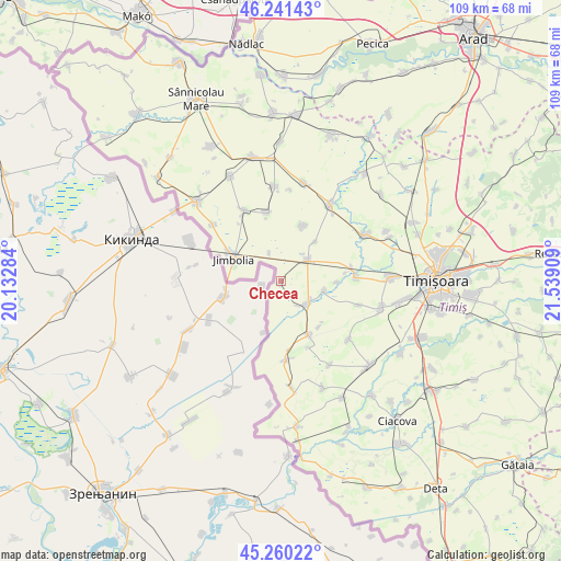
Checea GPS coordinates[2]
45° 45' 10.728" North, 20° 50' 9.456" East
| Map corner | latitude | longitude |
|---|---|---|
| Upper-left | 46.24143°, | 20.13284° |
| Center: | 45.75298°, | 20.83596° |
| Lower-right: | 45.26022°, | 21.53909° |
| Map W x H: | 109.1×109.1 km | = 67.8×67.8mi |
| max Lat: | 48.23793° ⇑50.8% North |
| Checea: | 45.75298° |
| min Lat: | ⇓49.2% South 43.65638° |
| min Long | Checea | max Long |
| 20.31667° | 20.83596° | 29.65403° |
| W 0.3%⇐ | ⇒99.7% E |
Elevation
Elevation of Checea is 77 m = 253 ft, and this is 177.9 m = 584 ft below average elevation for this country.
| Max E: |
1278 m = 4193 ft | 85.4% |
| Avg. | 254.9 m = 836 ft | |
| Checea | 77 m = 253 ft | |
Min E: |
-2 m = -7 ft | 14.6% |
See also: Romania elevation on elevation.city.
Geographical zone
Checea is located in North temperate zone (between Tropic of Cancer and the Arctic Circle). Distance of this North polar circle is 2313.9 km =1437.8 mi to North.| Distance of | km | miles | from Checea |
|---|---|---|---|
| North Pole | 4919.8 | 3057 | to North |
| Arctic Circle | 2313.9 | 1437.8 | to North |
| Tropic Cancer | 2481.3 | 1541.8 | to South |
| Equator | 5087.3 | 3161.1 | to South |


Nearby cities:
15 places around Checea: (largest is in red/bold)
• Beregsău Mare
14.8 km =9.2 mi,  87°
87°
• Beregsău Mic
11 km =6.8 mi, 90°
• Bobda
8.8 km =5.5 mi,  101°
101°
• Cenei
6.7 km =4.2 mi,  128°
128°
• Cărpiniş
6.5 km =4 mi,  54°
54°
• Grabăț
15.7 km =9.8 mi,  332°
332°
• Iecea Mare
11.7 km =7.3 mi,  22°
22°
• Iecea Mică
10.2 km =6.3 mi,  41°
41°
• Jimbolia
10.2 km =6.3 mi,  294°
294°
• Lenauheim
13.5 km =8.4 mi,  347°
347°
• Otelec
15.4 km =9.6 mi,  176°
176°
• Pustiniș
13.3 km =8.3 mi,  172°
172°
• Răuți
11.6 km =7.2 mi,  139°
139°
• Sânmihaiu German
15.8 km =9.8 mi,  107°
107°
• Uivar
11.9 km =7.4 mi,  152°
152°
Sources, notices
• [Note1] Compared only with cities in Romania existing in our database
• [Src1] Map data: © OpenStreetMap contributors (CC-BY-SA)
• [Src2] Other city data from geonames.org with taken over terms of usage.
• [Src3] Geographical zone / Annual Mean Temperature by Robert A. Rohde @ Wikipedia
