Grabăț geodata
Grabăț (Timiş) is a populated place; located in Romania in Europe/Bucharest (GMT+3) time zone. With population of 1,883 people, there are 2726 cities with bigger population in this country. Compared to other cities in Romania, 52.2% of cities are located further ↓South; 99.8% of cities are located further →East and 83.1% of cities have higher elevation than Grabăț. Note1


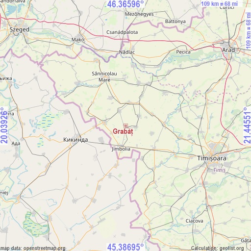
Grabăț GPS coordinates[2]
45° 52' 42.996" North, 20° 44' 32.568" East
| Map corner | latitude | longitude |
|---|---|---|
| Upper-left | 46.36596°, | 20.03926° |
| Center: | 45.87861°, | 20.74238° |
| Lower-right: | 45.38695°, | 21.44551° |
| Map W x H: | 108.9×108.9 km | = 67.7×67.7mi |
| max Lat: | 48.23793° ⇑47.8% North |
| Grabăț: | 45.87861° |
| min Lat: | ⇓52.2% South 43.65638° |
| min Long | Grabăț | max Long |
| 20.31667° | 20.74238° | 29.65403° |
| W 0.2%⇐ | ⇒99.8% E |
Elevation
Elevation of Grabăț is 84 m = 276 ft, and this is 170.9 m = 561 ft below average elevation for this country.
| Max E: |
1278 m = 4193 ft | 83.1% |
| Avg. | 254.9 m = 836 ft | |
| Grabăț | 84 m = 276 ft | |
Min E: |
-2 m = -7 ft | 16.9% |
See also: Romania elevation on elevation.city.
Geographical zone
Grabăț is located in North temperate zone (between Tropic of Cancer and the Arctic Circle). Distance of this North polar circle is 2300 km =1429.2 mi to North.| Distance of | km | miles | from Grabăț |
|---|---|---|---|
| North Pole | 4905.8 | 3048.3 | to North |
| Arctic Circle | 2300 | 1429.2 | to North |
| Tropic Cancer | 2495.3 | 1550.5 | to South |
| Equator | 5101.2 | 3169.7 | to South |


Nearby cities:
15 places around Grabăț: (largest is in red/bold)
• Bulgăruș
7.7 km =4.8 mi,  53°
53°
• Checea
15.7 km =9.8 mi,  152°
152°
• Comloşu Mare
9 km =5.6 mi,  278°
278°
• Comloșu Mic
6.4 km =4 mi,  242°
242°
• Gottlob
6.8 km =4.2 mi,  339°
339°
• Iecea Mare
12.1 km =7.5 mi,  104°
104°
• Iecea Mică
15.4 km =9.6 mi,  114°
114°
• Jimbolia
9.9 km =6.2 mi,  191°
191°
• Lenauheim
4.5 km =2.8 mi, 99°
• Lovrin
10.2 km =6.3 mi,  12°
12°
• Lunga
11.7 km =7.3 mi,  272°
272°
• Pesac
14.9 km =9.3 mi,  28°
28°
• Tomnatic
13.7 km =8.5 mi,  333°
333°
• Uihei
10 km =6.2 mi,  68°
68°
• Şandra
12.6 km =7.8 mi, 65°
Sources, notices
• [Note1] Compared only with cities in Romania existing in our database
• [Src1] Map data: © OpenStreetMap contributors (CC-BY-SA)
• [Src2] Other city data from geonames.org with taken over terms of usage.
• [Src3] Geographical zone / Annual Mean Temperature by Robert A. Rohde @ Wikipedia
