Odrihei geodata
Odrihei (Mureş) is a populated place; located in Romania in Europe/Bucharest (GMT+3) time zone. With population of 514 people, there are 6913 cities with bigger population in this country. Compared to other cities in Romania, 64.7% of cities are located further ↓South; 59.2% of cities are located further →East and 69.8% of cities have lower elevation than Odrihei. Note1


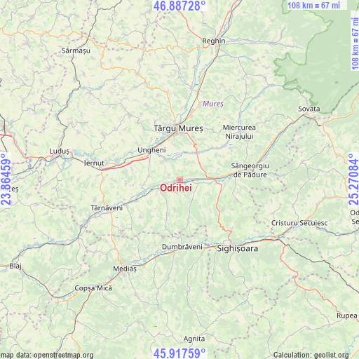
Odrihei GPS coordinates[2]
46° 24' 16.524" North, 24° 34' 3.756" East
| Map corner | latitude | longitude |
|---|---|---|
| Upper-left | 46.88728°, | 23.86459° |
| Center: | 46.40459°, | 24.56771° |
| Lower-right: | 45.91759°, | 25.27084° |
| Map W x H: | 107.8×107.8 km | = 67×67mi |
| max Lat: | 48.23793° ⇑35.3% North |
| Odrihei: | 46.40459° |
| min Lat: | ⇓64.7% South 43.65638° |
| min Long | Odrihei | max Long |
| 20.31667° | 24.56771° | 29.65403° |
| W 40.8%⇐ | ⇒59.2% E |
Elevation
Elevation of Odrihei is 319 m = 1047 ft, and this is 64.1 m = 210 ft above average elevation for this country.
| Max E: |
1278 m = 4193 ft | 30.2% |
| Odrihei | 319 m 1047 ft | |
| Avg. | 254.9 m = 836 ft | |
Min E: |
-2 m = -7 ft | 69.8% |
See also: Romania elevation on elevation.city.
Geographical zone
Odrihei is located in North temperate zone (between Tropic of Cancer and the Arctic Circle). Distance of this North polar circle is 2241.5 km =1392.8 mi to North.| Distance of | km | miles | from Odrihei |
|---|---|---|---|
| North Pole | 4847.4 | 3012 | to North |
| Arctic Circle | 2241.5 | 1392.8 | to North |
| Tropic Cancer | 2553.8 | 1586.9 | to South |
| Equator | 5159.7 | 3206.1 | to South |


Nearby cities:
15 places around Odrihei: (largest is in red/bold)
• Acăţari
9.7 km =6 mi,  30°
30°
• Agrișteu
9.1 km =5.7 mi,  98°
98°
• Bahnea
7.7 km =4.8 mi,  236°
236°
• Bălăuşeri
8.9 km =5.5 mi,  93°
93°
• Cerghid
9.4 km =5.8 mi,  276°
276°
• Cornești
5.7 km =3.5 mi,  12°
12°
• Coroisânmartin
2.5 km =1.6 mi, 101°
• Crăciuneşti
8.4 km =5.2 mi, 7°
• Gheorghe Doja
8.6 km =5.3 mi,  323°
323°
• Idrifaia
8.1 km =5 mi,  256°
256°
• Satu Nou
7.2 km =4.5 mi, 323°
• Senereuș
10.1 km =6.3 mi,  140°
140°
• Suplac
4.6 km =2.9 mi, 238°
• Tirimia
7.7 km =4.8 mi,  310°
310°
• Zagăr
7.1 km =4.4 mi,  148°
148°
Sources, notices
• [Note1] Compared only with cities in Romania existing in our database
• [Src1] Map data: © OpenStreetMap contributors (CC-BY-SA)
• [Src2] Other city data from geonames.org with taken over terms of usage.
• [Src3] Geographical zone / Annual Mean Temperature by Robert A. Rohde @ Wikipedia
