Runcurel geodata
Runcurel (Gorj) is a populated place; located in Romania in Europe/Bucharest (GMT+3) time zone. With population of 528 people, there are 6791 cities with bigger population in this country. Compared to other cities in Romania, 74.6% of cities are located further ↑North; 84.1% of cities are located further →East and 61.5% of cities have lower elevation than Runcurel. Note1


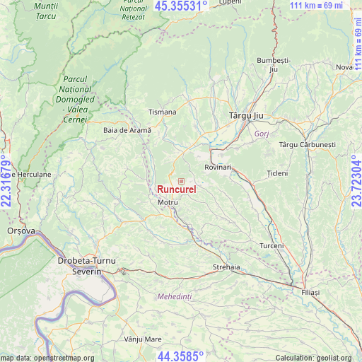
Runcurel GPS coordinates[2]
44° 51' 32.616" North, 23° 1' 11.676" East
| Map corner | latitude | longitude |
|---|---|---|
| Upper-left | 45.35531°, | 22.31679° |
| Center: | 44.85906°, | 23.01991° |
| Lower-right: | 44.3585°, | 23.72304° |
| Map W x H: | 110.8×110.8 km | = 68.8×68.8mi |
| max Lat: | 48.23793° ⇑74.6% North |
| Runcurel: | 44.85906° |
| min Lat: | ⇓25.4% South 43.65638° |
| min Long | Runcurel | max Long |
| 20.31667° | 23.01991° | 29.65403° |
| W 15.9%⇐ | ⇒84.1% E |
Elevation
Elevation of Runcurel is 272 m = 892 ft, and this is 17.1 m = 56 ft above average elevation for this country.
| Max E: |
1278 m = 4193 ft | 38.5% |
| Runcurel | 272 m 892 ft | |
| Avg. | 254.9 m = 836 ft | |
Min E: |
-2 m = -7 ft | 61.5% |
See also: Romania elevation on elevation.city.
Geographical zone
Runcurel is located in North temperate zone (between Tropic of Cancer and the Arctic Circle). Distance of this Northern Tropic circle is 2381.9 km =1480 mi to South.| Distance of | km | miles | from Runcurel |
|---|---|---|---|
| North Pole | 5019.2 | 3118.8 | to North |
| Arctic Circle | 2413.3 | 1499.6 | to North |
| Tropic Cancer | 2381.9 | 1480 | to South |
| Equator | 4987.9 | 3099.3 | to South |


Nearby cities:
15 places around Runcurel: (largest is in red/bold)
• Brădet
4.2 km =2.6 mi,  77°
77°
• Ciuperceni
8.3 km =5.2 mi,  358°
358°
• Croici
6.8 km =4.2 mi,  116°
116°
• Cătunele
8.9 km =5.5 mi,  273°
273°
• Horăști
8.1 km =5 mi,  183°
183°
• Lupoaia
6.8 km =4.2 mi,  223°
223°
• Meriș
9.1 km =5.7 mi,  201°
201°
• Miculești
4.4 km =2.7 mi,  152°
152°
• Motru
7.3 km =4.5 mi,  211°
211°
• Mătăsari
5.1 km =3.2 mi,  101°
101°
• Olteanu
8.4 km =5.2 mi,  290°
290°
• Pinoasa
8.2 km =5.1 mi,  48°
48°
• Ploștina
4.6 km =2.9 mi, 212°
• Roșiuța
3.1 km =1.9 mi, 267°
• Zegujani
10 km =6.2 mi,  235°
235°
Sources, notices
• [Note1] Compared only with cities in Romania existing in our database
• [Src1] Map data: © OpenStreetMap contributors (CC-BY-SA)
• [Src2] Other city data from geonames.org with taken over terms of usage.
• [Src3] Geographical zone / Annual Mean Temperature by Robert A. Rohde @ Wikipedia
