Castranova geodata
Castranova (Dolj) is a seat of a second-order administrative division; located in Romania in Europe/Bucharest (GMT+3) time zone. With population of 1,941 people, there are 2661 cities with bigger population in this country. Compared to other cities in Romania, 95.2% of cities are located further ↑North; 69.1% of cities are located further →East and 65.7% of cities have higher elevation than Castranova. Note1


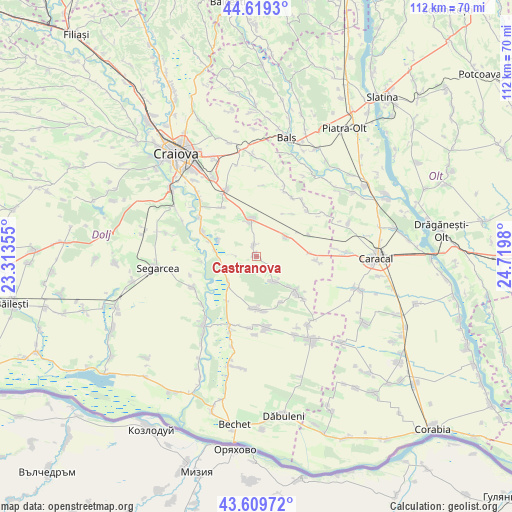
Castranova GPS coordinates[2]
44° 7' 0.012" North, 24° 1' 0.012" East
| Map corner | latitude | longitude |
|---|---|---|
| Upper-left | 44.6193°, | 23.31355° |
| Center: | 44.11667°, | 24.01667° |
| Lower-right: | 43.60972°, | 24.7198° |
| Map W x H: | 112.3×112.3 km | = 69.8×69.8mi |
| max Lat: | 48.23793° ⇑95.2% North |
| Castranova: | 44.11667° |
| min Lat: | ⇓4.8% South 43.65638° |
| min Long | Castranova | max Long |
| 20.31667° | 24.01667° | 29.65403° |
| W 30.9%⇐ | ⇒69.1% E |
Elevation
Elevation of Castranova is 144 m = 472 ft, and this is 110.9 m = 364 ft below average elevation for this country.
| Max E: |
1278 m = 4193 ft | 65.7% |
| Avg. | 254.9 m = 836 ft | |
| Castranova | 144 m = 472 ft | |
Min E: |
-2 m = -7 ft | 34.3% |
See also: Romania elevation on elevation.city.
Geographical zone
Castranova is located in North temperate zone (between Tropic of Cancer and the Arctic Circle). Distance of this Northern Tropic circle is 2299.4 km =1428.8 mi to South.| Distance of | km | miles | from Castranova |
|---|---|---|---|
| North Pole | 5101.7 | 3170 | to North |
| Arctic Circle | 2495.9 | 1550.9 | to North |
| Tropic Cancer | 2299.4 | 1428.8 | to South |
| Equator | 4905.3 | 3048 | to South |


Nearby cities:
15 places around Castranova: (largest is in red/bold)
• Apele Vii
6.8 km =4.2 mi,  144°
144°
• Bratovoești
9.5 km =5.9 mi,  281°
281°
• Bădoși
10.7 km =6.6 mi,  288°
288°
• Celaru
11.9 km =7.4 mi,  128°
128°
• Ciocănești
12.6 km =7.8 mi,  67°
67°
• Georocu Mare
5.3 km =3.3 mi, 275°
• Ghizdăvești
9.8 km =6.1 mi, 131°
• Leu
7.5 km =4.7 mi,  349°
349°
• Marotinu de Sus
11.5 km =7.1 mi,  151°
151°
• Mârşani
11.1 km =6.9 mi,  180°
180°
• Puțuri
2.5 km =1.6 mi, 347°
• Radomir
12.1 km =7.5 mi,  87°
87°
• Rojiște
8.3 km =5.2 mi,  228°
228°
• Soreni
11.4 km =7.1 mi, 128°
• Zănoaga
7.8 km =4.8 mi,  56°
56°
Sources, notices
• [Note1] Compared only with cities in Romania existing in our database
• [Src1] Map data: © OpenStreetMap contributors (CC-BY-SA)
• [Src2] Other city data from geonames.org with taken over terms of usage.
• [Src3] Geographical zone / Annual Mean Temperature by Robert A. Rohde @ Wikipedia
