Puțuri geodata
Puțuri (Dolj) is a populated place; located in Romania in Europe/Bucharest (GMT+3) time zone. With population of 1,641 people, there are 2990 cities with bigger population in this country. Compared to other cities in Romania, 94.7% of cities are located further ↑North; 69.3% of cities are located further →East and 62.7% of cities have higher elevation than Puțuri. Note1


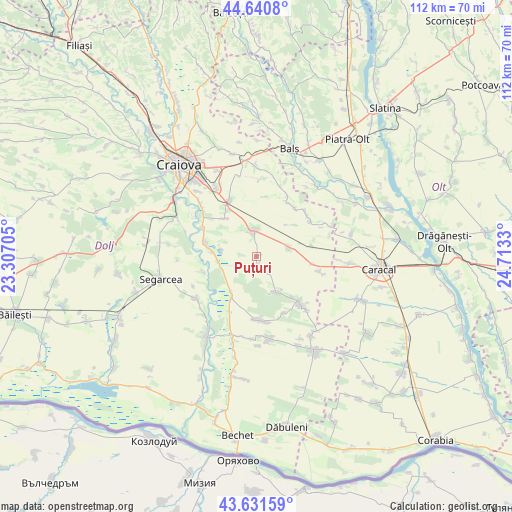
Puțuri GPS coordinates[2]
44° 8' 18.06" North, 24° 0' 36.612" East
| Map corner | latitude | longitude |
|---|---|---|
| Upper-left | 44.6408°, | 23.30705° |
| Center: | 44.13835°, | 24.01017° |
| Lower-right: | 43.63159°, | 24.7133° |
| Map W x H: | 112.2×112.2 km | = 69.7×69.7mi |
| max Lat: | 48.23793° ⇑94.7% North |
| Puțuri: | 44.13835° |
| min Lat: | ⇓5.3% South 43.65638° |
| min Long | Puțuri | max Long |
| 20.31667° | 24.01017° | 29.65403° |
| W 30.7%⇐ | ⇒69.3% E |
Elevation
Elevation of Puțuri is 156 m = 512 ft, and this is 98.9 m = 324 ft below average elevation for this country.
| Max E: |
1278 m = 4193 ft | 62.7% |
| Avg. | 254.9 m = 836 ft | |
| Puțuri | 156 m = 512 ft | |
Min E: |
-2 m = -7 ft | 37.3% |
See also: Romania elevation on elevation.city.
Geographical zone
Puțuri is located in North temperate zone (between Tropic of Cancer and the Arctic Circle). Distance of this Northern Tropic circle is 2301.8 km =1430.3 mi to South.| Distance of | km | miles | from Puțuri |
|---|---|---|---|
| North Pole | 5099.3 | 3168.6 | to North |
| Arctic Circle | 2493.4 | 1549.3 | to North |
| Tropic Cancer | 2301.8 | 1430.3 | to South |
| Equator | 4907.7 | 3049.5 | to South |


Nearby cities:
15 places around Puțuri: (largest is in red/bold)
• Apele Vii
9.2 km =5.7 mi,  150°
150°
• Bratovoești
8.8 km =5.5 mi,  266°
266°
• Bădoși
9.7 km =6 mi,  275°
275°
• Castranova
2.5 km =1.6 mi,  167°
167°
• Ciocănești
12.4 km =7.7 mi,  78°
78°
• Georocu Mare
5.1 km =3.2 mi,  247°
247°
• Ghindeni
10.7 km =6.6 mi,  319°
319°
• Ghizdăvești
11.9 km =7.4 mi,  138°
138°
• Leu
5.1 km =3.2 mi,  350°
350°
• Radomir
12.8 km =8 mi,  98°
98°
• Rojiște
9.8 km =6.1 mi,  215°
215°
• Secui
13.1 km =8.1 mi,  296°
296°
• Teasc
12 km =7.5 mi, 284°
• Viișoara
13.2 km =8.2 mi,  37°
37°
• Zănoaga
7.3 km =4.5 mi, 75°
Sources, notices
• [Note1] Compared only with cities in Romania existing in our database
• [Src1] Map data: © OpenStreetMap contributors (CC-BY-SA)
• [Src2] Other city data from geonames.org with taken over terms of usage.
• [Src3] Geographical zone / Annual Mean Temperature by Robert A. Rohde @ Wikipedia
