Apele Vii geodata
Apele Vii (Dolj) is a seat of a second-order administrative division; located in Romania in Europe/Bucharest (GMT+3) time zone. With population of 2,462 people, there are 2194 cities with bigger population in this country. Compared to other cities in Romania, 96% of cities are located further ↑North; 68.3% of cities are located further →East and 66.8% of cities have higher elevation than Apele Vii. Note1


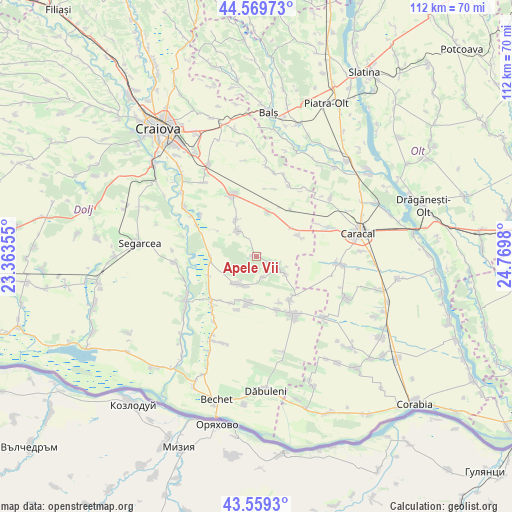
Apele Vii GPS coordinates[2]
44° 4' 0.012" North, 24° 4' 0.012" East
| Map corner | latitude | longitude |
|---|---|---|
| Upper-left | 44.56973°, | 23.36355° |
| Center: | 44.06667°, | 24.06667° |
| Lower-right: | 43.5593°, | 24.7698° |
| Map W x H: | 112.3×112.3 km | = 69.8×69.8mi |
| max Lat: | 48.23793° ⇑96% North |
| Apele Vii: | 44.06667° |
| min Lat: | ⇓4% South 43.65638° |
| min Long | Apele Vii | max Long |
| 20.31667° | 24.06667° | 29.65403° |
| W 31.7%⇐ | ⇒68.3% E |
Elevation
Elevation of Apele Vii is 140 m = 459 ft, and this is 114.9 m = 377 ft below average elevation for this country.
| Max E: |
1278 m = 4193 ft | 66.8% |
| Avg. | 254.9 m = 836 ft | |
| Apele Vii | 140 m = 459 ft | |
Min E: |
-2 m = -7 ft | 33.2% |
See also: Romania elevation on elevation.city.
Geographical zone
Apele Vii is located in North temperate zone (between Tropic of Cancer and the Arctic Circle). Distance of this Northern Tropic circle is 2293.8 km =1425.3 mi to South.| Distance of | km | miles | from Apele Vii |
|---|---|---|---|
| North Pole | 5107.3 | 3173.5 | to North |
| Arctic Circle | 2501.4 | 1554.3 | to North |
| Tropic Cancer | 2293.8 | 1425.3 | to South |
| Equator | 4899.8 | 3044.6 | to South |


Nearby cities:
15 places around Apele Vii: (largest is in red/bold)
• Braniște
10.4 km =6.5 mi,  204°
204°
• Castranova
6.8 km =4.2 mi,  324°
324°
• Celaru
5.6 km =3.5 mi,  109°
109°
• Dioşti
10.8 km =6.7 mi,  59°
59°
• Dăneţi
9.4 km =5.8 mi,  188°
188°
• Georocu Mare
11 km =6.8 mi,  303°
303°
• Ghizdăvești
3.5 km =2.2 mi, 106°
• Marotinu de Jos
7.5 km =4.7 mi,  121°
121°
• Marotinu de Sus
4.7 km =2.9 mi,  162°
162°
• Mârşani
6.8 km =4.2 mi,  215°
215°
• Puțuri
9.2 km =5.7 mi,  330°
330°
• Radomir
10.1 km =6.3 mi,  53°
53°
• Rojiște
10.2 km =6.3 mi,  270°
270°
• Soreni
5.1 km =3.2 mi, 108°
• Zănoaga
10.2 km =6.3 mi,  14°
14°
Sources, notices
• [Note1] Compared only with cities in Romania existing in our database
• [Src1] Map data: © OpenStreetMap contributors (CC-BY-SA)
• [Src2] Other city data from geonames.org with taken over terms of usage.
• [Src3] Geographical zone / Annual Mean Temperature by Robert A. Rohde @ Wikipedia
