Caraşova geodata
Caraşova (Caraş-Severin) is a seat of a second-order administrative division; located in Romania in Europe/Bucharest (GMT+3) time zone. With population of 3,153 people, there are 1654 cities with bigger population in this country. Compared to other cities in Romania, 61.7% of cities are located further ↑North; 95.3% of cities are located further →East and 63.4% of cities have lower elevation than Caraşova. Note1


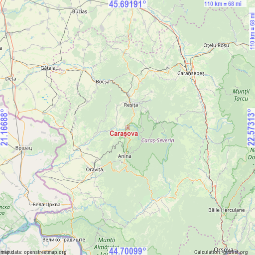
Caraşova GPS coordinates[2]
45° 11' 54.996" North, 21° 52' 12" East
| Map corner | latitude | longitude |
|---|---|---|
| Upper-left | 45.69191°, | 21.16688° |
| Center: | 45.19861°, | 21.87° |
| Lower-right: | 44.70099°, | 22.57313° |
| Map W x H: | 110.2×110.2 km | = 68.5×68.5mi |
| max Lat: | 48.23793° ⇑61.7% North |
| Caraşova: | 45.19861° |
| min Lat: | ⇓38.3% South 43.65638° |
| min Long | Caraşova | max Long |
| 20.31667° | 21.87° | 29.65403° |
| W 4.7%⇐ | ⇒95.3% E |
Elevation
Elevation of Caraşova is 281 m = 922 ft, and this is 26.1 m = 86 ft above average elevation for this country.
| Max E: |
1278 m = 4193 ft | 36.6% |
| Caraşova | 281 m 922 ft | |
| Avg. | 254.9 m = 836 ft | |
Min E: |
-2 m = -7 ft | 63.4% |
See also: Romania elevation on elevation.city.
Geographical zone
Caraşova is located in North temperate zone (between Tropic of Cancer and the Arctic Circle). Distance of this North polar circle is 2375.6 km =1476.1 mi to North.| Distance of | km | miles | from Caraşova |
|---|---|---|---|
| North Pole | 4981.4 | 3095.3 | to North |
| Arctic Circle | 2375.6 | 1476.1 | to North |
| Tropic Cancer | 2419.7 | 1503.5 | to South |
| Equator | 5025.6 | 3122.8 | to South |


Nearby cities:
15 places around Caraşova: (largest is in red/bold)
• Anina
13.3 km =8.3 mi,  184°
184°
• Ciudanoviţa
8.2 km =5.1 mi,  223°
223°
• Clocotici
5.8 km =3.6 mi,  331°
331°
• Câlnic
15.6 km =9.7 mi,  356°
356°
• Dognecea
12.2 km =7.6 mi,  313°
313°
• Doman
8.3 km =5.2 mi,  26°
26°
• Goruia
7.2 km =4.5 mi,  259°
259°
• Lupac
10.1 km =6.3 mi, 333°
• Nermed
3.5 km =2.2 mi,  351°
351°
• Rafnic
7.5 km =4.7 mi,  300°
300°
• Reşiţa
11.5 km =7.1 mi,  7°
7°
• Secu
11.7 km =7.3 mi,  47°
47°
• Steierdorf
15.1 km =9.4 mi,  185°
185°
• Văliug
13.4 km =8.3 mi,  73°
73°
• Țerova
12.9 km =8 mi,  19°
19°
Sources, notices
• [Note1] Compared only with cities in Romania existing in our database
• [Src1] Map data: © OpenStreetMap contributors (CC-BY-SA)
• [Src2] Other city data from geonames.org with taken over terms of usage.
• [Src3] Geographical zone / Annual Mean Temperature by Robert A. Rohde @ Wikipedia
