Căpeni geodata
Căpeni (Covasna) is a populated place; located in Romania in Europe/Bucharest (GMT+3) time zone. With population of 1,213 people, there are 3718 cities with bigger population in this country. Compared to other cities in Romania, 55.9% of cities are located further ↓South; 55.8% of cities are located further ←West and 87.1% of cities have lower elevation than Căpeni. Note1


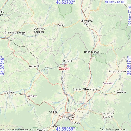
Căpeni GPS coordinates[2]
46° 2' 27.996" North, 25° 34' 42.888" East
| Map corner | latitude | longitude |
|---|---|---|
| Upper-left | 46.52702°, | 24.87546° |
| Center: | 46.04111°, | 25.57858° |
| Lower-right: | 45.55089°, | 26.28171° |
| Map W x H: | 108.5×108.5 km | = 67.4×67.4mi |
| max Lat: | 48.23793° ⇑44.1% North |
| Căpeni: | 46.04111° |
| min Lat: | ⇓55.9% South 43.65638° |
| min Long | Căpeni | max Long |
| 20.31667° | 25.57858° | 29.65403° |
| W 55.8%⇐ | ⇒44.2% E |
Elevation
Elevation of Căpeni is 471 m = 1545 ft, and this is 216.1 m = 709 ft above average elevation for this country.
| Max E: |
1278 m = 4193 ft | 12.9% |
| Căpeni | 471 m 1545 ft | |
| Avg. | 254.9 m = 836 ft | |
Min E: |
-2 m = -7 ft | 87.1% |
See also: Romania elevation on elevation.city.
Geographical zone
Căpeni is located in North temperate zone (between Tropic of Cancer and the Arctic Circle). Distance of this North polar circle is 2281.9 km =1417.9 mi to North.| Distance of | km | miles | from Căpeni |
|---|---|---|---|
| North Pole | 4887.8 | 3037.1 | to North |
| Arctic Circle | 2281.9 | 1417.9 | to North |
| Tropic Cancer | 2513.4 | 1561.8 | to South |
| Equator | 5119.3 | 3181 | to South |


Nearby cities:
15 places around Căpeni: (largest is in red/bold)
• Aita Mare
8.6 km =5.3 mi,  194°
194°
• Aita Medie
7.7 km =4.8 mi,  160°
160°
• Aita Seacă
9 km =5.6 mi,  91°
91°
• Apaţa
11.2 km =7 mi,  205°
205°
• Augustin
2 km =1.2 mi,  285°
285°
• Baraolt
4.1 km =2.5 mi,  23°
23°
• Biborțeni
8.3 km =5.2 mi,  44°
44°
• Brăduţ
10.7 km =6.6 mi, 15°
• Băţanii Mari
9.3 km =5.8 mi,  59°
59°
• Doboșeni
9.3 km =5.8 mi,  7°
7°
• Micloșoara
3.7 km =2.3 mi,  176°
176°
• Ormeniş
3.5 km =2.2 mi,  219°
219°
• Racoșul de Sus
5.9 km =3.7 mi,  323°
323°
• Tălișoara
7.2 km =4.5 mi, 6°
• Vârghiş
10.8 km =6.7 mi,  341°
341°
Sources, notices
• [Note1] Compared only with cities in Romania existing in our database
• [Src1] Map data: © OpenStreetMap contributors (CC-BY-SA)
• [Src2] Other city data from geonames.org with taken over terms of usage.
• [Src3] Geographical zone / Annual Mean Temperature by Robert A. Rohde @ Wikipedia
