Apaţa geodata
Apaţa (Braşov) is a seat of a second-order administrative division; located in Romania in Europe/Bucharest (GMT+3) time zone. With population of 2,929 people, there are 1830 cities with bigger population in this country. Compared to other cities in Romania, 54% of cities are located further ↓South; 54.7% of cities are located further ←West and 90.7% of cities have lower elevation than Apaţa. Note1


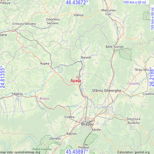
Apaţa GPS coordinates[2]
45° 57' 0" North, 25° 31' 0.012" East
| Map corner | latitude | longitude |
|---|---|---|
| Upper-left | 46.43672°, | 24.81355° |
| Center: | 45.95°, | 25.51667° |
| Lower-right: | 45.45897°, | 26.2198° |
| Map W x H: | 108.7×108.7 km | = 67.5×67.5mi |
| max Lat: | 48.23793° ⇑46% North |
| Apaţa: | 45.95° |
| min Lat: | ⇓54% South 43.65638° |
| min Long | Apaţa | max Long |
| 20.31667° | 25.51667° | 29.65403° |
| W 54.7%⇐ | ⇒45.3% E |
Elevation
Elevation of Apaţa is 525 m = 1722 ft, and this is 270.1 m = 886 ft above average elevation for this country.
| Max E: |
1278 m = 4193 ft | 9.3% |
| Apaţa | 525 m 1722 ft | |
| Avg. | 254.9 m = 836 ft | |
Min E: |
-2 m = -7 ft | 90.7% |
See also: Romania elevation on elevation.city.
Geographical zone
Apaţa is located in North temperate zone (between Tropic of Cancer and the Arctic Circle). Distance of this North polar circle is 2292 km =1424.2 mi to North.| Distance of | km | miles | from Apaţa |
|---|---|---|---|
| North Pole | 4897.9 | 3043.4 | to North |
| Arctic Circle | 2292 | 1424.2 | to North |
| Tropic Cancer | 2503.2 | 1555.4 | to South |
| Equator | 5109.2 | 3174.7 | to South |


Nearby cities:
15 places around Apaţa: (largest is in red/bold)
• Aita Mare
3.2 km =2 mi,  54°
54°
• Aita Medie
7.9 km =4.9 mi,  68°
68°
• Arini
8 km =5 mi,  151°
151°
• Augustin
11.1 km =6.9 mi,  14°
14°
• Belin
4.3 km =2.7 mi,  115°
115°
• Belin-Vale
7.4 km =4.6 mi,  105°
105°
• Colonia Reconstrucția
14.3 km =8.9 mi,  162°
162°
• Căpeni
11.2 km =7 mi,  25°
25°
• Dopca
10.8 km =6.7 mi,  290°
290°
• Hăghig
14 km =8.7 mi, 158°
• Micloșoara
8.2 km =5.1 mi,  37°
37°
• Măieruş
5.7 km =3.5 mi,  166°
166°
• Ormeniş
7.8 km =4.8 mi,  19°
19°
• Racoș
11.7 km =7.3 mi,  315°
315°
• Rotbav
12.7 km =7.9 mi, 165°
Sources, notices
• [Note1] Compared only with cities in Romania existing in our database
• [Src1] Map data: © OpenStreetMap contributors (CC-BY-SA)
• [Src2] Other city data from geonames.org with taken over terms of usage.
• [Src3] Geographical zone / Annual Mean Temperature by Robert A. Rohde @ Wikipedia
