Augustin geodata
Augustin (Braşov) is a seat of a second-order administrative division; located in Romania in Europe/Bucharest (GMT+3) time zone. With population of 1,207 people, there are 3725 cities with bigger population in this country. Compared to other cities in Romania, 56% of cities are located further ↓South; 55.4% of cities are located further ←West and 86.7% of cities have lower elevation than Augustin. Note1


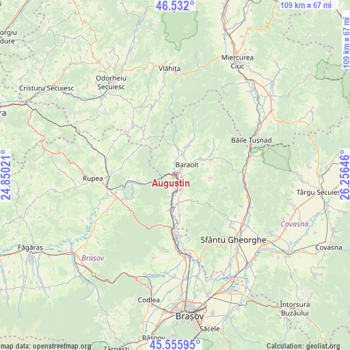
Augustin GPS coordinates[2]
46° 2' 46.068" North, 25° 33' 11.988" East
| Map corner | latitude | longitude |
|---|---|---|
| Upper-left | 46.532°, | 24.85021° |
| Center: | 46.04613°, | 25.55333° |
| Lower-right: | 45.55595°, | 26.25646° |
| Map W x H: | 108.5×108.5 km | = 67.4×67.4mi |
| max Lat: | 48.23793° ⇑44% North |
| Augustin: | 46.04613° |
| min Lat: | ⇓56% South 43.65638° |
| min Long | Augustin | max Long |
| 20.31667° | 25.55333° | 29.65403° |
| W 55.4%⇐ | ⇒44.6% E |
Elevation
Elevation of Augustin is 465 m = 1526 ft, and this is 210.1 m = 689 ft above average elevation for this country.
| Max E: |
1278 m = 4193 ft | 13.3% |
| Augustin | 465 m 1526 ft | |
| Avg. | 254.9 m = 836 ft | |
Min E: |
-2 m = -7 ft | 86.7% |
See also: Romania elevation on elevation.city.
Geographical zone
Augustin is located in North temperate zone (between Tropic of Cancer and the Arctic Circle). Distance of this North polar circle is 2281.3 km =1417.5 mi to North.| Distance of | km | miles | from Augustin |
|---|---|---|---|
| North Pole | 4887.2 | 3036.8 | to North |
| Arctic Circle | 2281.3 | 1417.5 | to North |
| Tropic Cancer | 2513.9 | 1562.1 | to South |
| Equator | 5119.8 | 3181.3 | to South |


Nearby cities:
15 places around Augustin: (largest is in red/bold)
• Aita Mare
8.8 km =5.5 mi,  181°
181°
• Aita Medie
9.1 km =5.7 mi,  149°
149°
• Aita Seacă
10.9 km =6.8 mi,  94°
94°
• Apaţa
11.1 km =6.9 mi,  194°
194°
• Baraolt
4.9 km =3 mi,  48°
48°
• Biborțeni
9.5 km =5.9 mi,  55°
55°
• Brăduţ
10.9 km =6.8 mi,  26°
26°
• Băţanii Mari
10.8 km =6.7 mi,  67°
67°
• Căpeni
2 km =1.2 mi,  105°
105°
• Doboșeni
9.2 km =5.7 mi,  19°
19°
• Micloșoara
4.8 km =3 mi, 152°
• Ormeniş
3.3 km =2.1 mi, 184°
• Racoșul de Sus
4.4 km =2.7 mi,  339°
339°
• Tălișoara
7.1 km =4.4 mi, 22°
• Vârghiş
9.8 km =6.1 mi,  350°
350°
Sources, notices
• [Note1] Compared only with cities in Romania existing in our database
• [Src1] Map data: © OpenStreetMap contributors (CC-BY-SA)
• [Src2] Other city data from geonames.org with taken over terms of usage.
• [Src3] Geographical zone / Annual Mean Temperature by Robert A. Rohde @ Wikipedia
