Călineşti geodata
Călineşti (Arges) is a seat of a second-order administrative division; located in Romania in Europe/Bucharest (GMT+3) time zone. With population of 10,419 people, there are 198 cities with bigger population in this country. Compared to other cities in Romania, 76.2% of cities are located further ↑North; 52% of cities are located further →East and 55.4% of cities have lower elevation than Călineşti. Note1


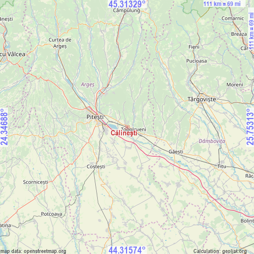
Călineşti GPS coordinates[2]
44° 49' 0.012" North, 25° 3' 0" East
| Map corner | latitude | longitude |
|---|---|---|
| Upper-left | 45.31329°, | 24.34688° |
| Center: | 44.81667°, | 25.05° |
| Lower-right: | 44.31574°, | 25.75313° |
| Map W x H: | 110.9×110.9 km | = 68.9×68.9mi |
| max Lat: | 48.23793° ⇑76.2% North |
| Călineşti: | 44.81667° |
| min Lat: | ⇓23.8% South 43.65638° |
| min Long | Călineşti | max Long |
| 20.31667° | 25.05° | 29.65403° |
| W 48%⇐ | ⇒52% E |
Elevation
Elevation of Călineşti is 240 m = 787 ft, and this is 14.9 m = 49 ft below average elevation for this country.
| Max E: |
1278 m = 4193 ft | 44.6% |
| Avg. | 254.9 m = 836 ft | |
| Călineşti | 240 m = 787 ft | |
Min E: |
-2 m = -7 ft | 55.4% |
See also: Romania elevation on elevation.city.
Geographical zone
Călineşti is located in North temperate zone (between Tropic of Cancer and the Arctic Circle). Distance of this Northern Tropic circle is 2377.2 km =1477.1 mi to South.| Distance of | km | miles | from Călineşti |
|---|---|---|---|
| North Pole | 5023.9 | 3121.7 | to North |
| Arctic Circle | 2418 | 1502.5 | to North |
| Tropic Cancer | 2377.2 | 1477.1 | to South |
| Equator | 4983.1 | 3096.4 | to South |


Nearby cities:
15 places around Călineşti: (largest is in red/bold)
• Ciocănești
7.5 km =4.7 mi,  301°
301°
• Cireșu
6.3 km =3.9 mi,  189°
189°
• Căteasca
6.2 km =3.9 mi,  154°
154°
• Glâmbocelu
7.5 km =4.7 mi,  70°
70°
• Golești
7.2 km =4.5 mi,  290°
290°
• Gorganu
3 km =1.9 mi,  342°
342°
• Leordeni
6.4 km =4 mi,  125°
125°
• Popeşti
5.7 km =3.5 mi,  166°
166°
• Radu Negru
6 km =3.7 mi,  328°
328°
• Topoloveni
2.6 km =1.6 mi,  90°
90°
• Udeni-Zăvoi
4.3 km =2.7 mi, 288°
• Urlucea
5.8 km =3.6 mi,  346°
346°
• Valea Popii
6.3 km =3.9 mi,  27°
27°
• Vrănești
4.7 km =2.9 mi,  313°
313°
• Văleni-Podgoria
6.6 km =4.1 mi, 313°
Sources, notices
• [Note1] Compared only with cities in Romania existing in our database
• [Src1] Map data: © OpenStreetMap contributors (CC-BY-SA)
• [Src2] Other city data from geonames.org with taken over terms of usage.
• [Src3] Geographical zone / Annual Mean Temperature by Robert A. Rohde @ Wikipedia
