Leordeni geodata
Leordeni (Arges) is a seat of a second-order administrative division; located in Romania in Europe/Bucharest (GMT+3) time zone. With population of 6,019 people, there are 543 cities with bigger population in this country. Compared to other cities in Romania, 77.4% of cities are located further ↑North; 51.2% of cities are located further →East and 52.5% of cities have lower elevation than Leordeni. Note1


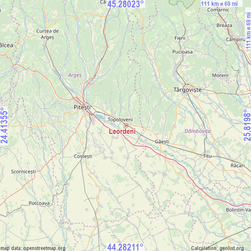
Leordeni GPS coordinates[2]
44° 46' 59.988" North, 25° 7' 0.012" East
| Map corner | latitude | longitude |
|---|---|---|
| Upper-left | 45.28023°, | 24.41355° |
| Center: | 44.78333°, | 25.11667° |
| Lower-right: | 44.28211°, | 25.8198° |
| Map W x H: | 111×111 km | = 69×69mi |
| max Lat: | 48.23793° ⇑77.4% North |
| Leordeni: | 44.78333° |
| min Lat: | ⇓22.6% South 43.65638° |
| min Long | Leordeni | max Long |
| 20.31667° | 25.11667° | 29.65403° |
| W 48.8%⇐ | ⇒51.2% E |
Elevation
Elevation of Leordeni is 224 m = 735 ft, and this is 30.9 m = 101 ft below average elevation for this country.
| Max E: |
1278 m = 4193 ft | 47.5% |
| Avg. | 254.9 m = 836 ft | |
| Leordeni | 224 m = 735 ft | |
Min E: |
-2 m = -7 ft | 52.5% |
See also: Romania elevation on elevation.city.
Geographical zone
Leordeni is located in North temperate zone (between Tropic of Cancer and the Arctic Circle). Distance of this Northern Tropic circle is 2373.5 km =1474.8 mi to South.| Distance of | km | miles | from Leordeni |
|---|---|---|---|
| North Pole | 5027.6 | 3124 | to North |
| Arctic Circle | 2421.7 | 1504.8 | to North |
| Tropic Cancer | 2373.5 | 1474.8 | to South |
| Equator | 4979.4 | 3094.1 | to South |


Nearby cities:
15 places around Leordeni: (largest is in red/bold)
• Cireșu
6.8 km =4.2 mi,  247°
247°
• Ciulnița
3 km =1.9 mi,  80°
80°
• Călineşti
6.4 km =4 mi,  305°
305°
• Căteasca
3.2 km =2 mi,  234°
234°
• Furduești
6.6 km =4.1 mi,  187°
187°
• Glâmbocata-Deal
4.8 km =3 mi,  91°
91°
• Glâmbocelu
6.5 km =4 mi,  16°
16°
• Gruiu
6.5 km =4 mi,  214°
214°
• Popeşti
4.4 km =2.7 mi,  244°
244°
• Pătuleni
6.8 km =4.2 mi,  146°
146°
• Răteşti
5.7 km =3.5 mi,  166°
166°
• Schitu Scoicești
4.5 km =2.8 mi,  35°
35°
• Siliștea
7.5 km =4.7 mi, 229°
• Tigveni
6 km =3.7 mi, 151°
• Topoloveni
4.5 km =2.8 mi,  324°
324°
Sources, notices
• [Note1] Compared only with cities in Romania existing in our database
• [Src1] Map data: © OpenStreetMap contributors (CC-BY-SA)
• [Src2] Other city data from geonames.org with taken over terms of usage.
• [Src3] Geographical zone / Annual Mean Temperature by Robert A. Rohde @ Wikipedia
