Popeşti geodata
Popeşti (Arges) is a populated place; located in Romania in Europe/Bucharest (GMT+3) time zone. With population of 4,104 people, there are 1129 cities with bigger population in this country. Compared to other cities in Romania, 77.9% of cities are located further ↑North; 51.8% of cities are located further →East and 55.6% of cities have lower elevation than Popeşti. Note1


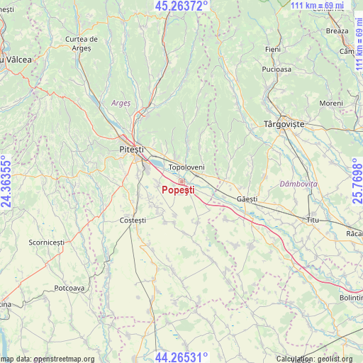
Popeşti GPS coordinates[2]
44° 46' 0.012" North, 25° 4' 0.012" East
| Map corner | latitude | longitude |
|---|---|---|
| Upper-left | 45.26372°, | 24.36355° |
| Center: | 44.76667°, | 25.06667° |
| Lower-right: | 44.26531°, | 25.7698° |
| Map W x H: | 111×111 km | = 69×69mi |
| max Lat: | 48.23793° ⇑77.9% North |
| Popeşti: | 44.76667° |
| min Lat: | ⇓22.1% South 43.65638° |
| min Long | Popeşti | max Long |
| 20.31667° | 25.06667° | 29.65403° |
| W 48.2%⇐ | ⇒51.8% E |
Elevation
Elevation of Popeşti is 241 m = 791 ft, and this is 13.9 m = 46 ft below average elevation for this country.
| Max E: |
1278 m = 4193 ft | 44.4% |
| Avg. | 254.9 m = 836 ft | |
| Popeşti | 241 m = 791 ft | |
Min E: |
-2 m = -7 ft | 55.6% |
See also: Romania elevation on elevation.city.
Geographical zone
Popeşti is located in North temperate zone (between Tropic of Cancer and the Arctic Circle). Distance of this Northern Tropic circle is 2371.7 km =1473.7 mi to South.| Distance of | km | miles | from Popeşti |
|---|---|---|---|
| North Pole | 5029.5 | 3125.2 | to North |
| Arctic Circle | 2423.6 | 1506 | to North |
| Tropic Cancer | 2371.7 | 1473.7 | to South |
| Equator | 4977.6 | 3092.9 | to South |


Nearby cities:
15 places around Popeşti: (largest is in red/bold)
• Cireșu
2.4 km =1.5 mi,  253°
253°
• Ciulnița
7.3 km =4.5 mi,  71°
71°
• Călineşti
5.7 km =3.5 mi,  346°
346°
• Căteasca
1.3 km =0.8 mi,  90°
90°
• Furduești
5.6 km =3.5 mi,  146°
146°
• Gruiu
3.5 km =2.2 mi,  175°
175°
• Leordeni
4.4 km =2.7 mi,  64°
64°
• Oarja
7.2 km =4.5 mi,  264°
264°
• Oarja Sat
7.5 km =4.7 mi,  267°
267°
• Pătuleni
8.6 km =5.3 mi,  116°
116°
• Răteşti
6.4 km =4 mi,  125°
125°
• Schitu Scoicești
8.6 km =5.3 mi,  50°
50°
• Siliștea
3.5 km =2.2 mi,  209°
209°
• Tigveni
7.6 km =4.7 mi, 116°
• Topoloveni
5.7 km =3.5 mi,  13°
13°
Sources, notices
• [Note1] Compared only with cities in Romania existing in our database
• [Src1] Map data: © OpenStreetMap contributors (CC-BY-SA)
• [Src2] Other city data from geonames.org with taken over terms of usage.
• [Src3] Geographical zone / Annual Mean Temperature by Robert A. Rohde @ Wikipedia
