Burdea geodata
Burdea (Arges) is a populated place; located in Romania in Europe/Bucharest (GMT+3) time zone. With population of 844 people, there are 4867 cities with bigger population in this country. Compared to other cities in Romania, 86.8% of cities are located further ↑North; 54.1% of cities are located further →East and 56.6% of cities have higher elevation than Burdea. Note1


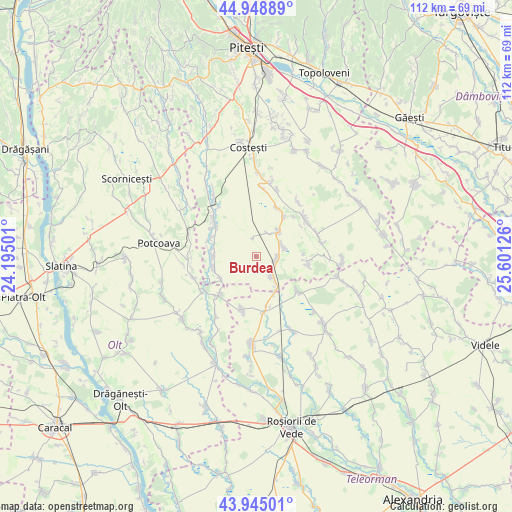
Burdea GPS coordinates[2]
44° 26' 56.796" North, 24° 53' 53.268" East
| Map corner | latitude | longitude |
|---|---|---|
| Upper-left | 44.94889°, | 24.19501° |
| Center: | 44.44911°, | 24.89813° |
| Lower-right: | 43.94501°, | 25.60126° |
| Map W x H: | 111.6×111.6 km | = 69.3×69.3mi |
| max Lat: | 48.23793° ⇑86.8% North |
| Burdea: | 44.44911° |
| min Lat: | ⇓13.2% South 43.65638° |
| min Long | Burdea | max Long |
| 20.31667° | 24.89813° | 29.65403° |
| W 45.9%⇐ | ⇒54.1% E |
Elevation
Elevation of Burdea is 180 m = 591 ft, and this is 74.9 m = 246 ft below average elevation for this country.
| Max E: |
1278 m = 4193 ft | 56.6% |
| Avg. | 254.9 m = 836 ft | |
| Burdea | 180 m = 591 ft | |
Min E: |
-2 m = -7 ft | 43.4% |
See also: Romania elevation on elevation.city.
Geographical zone
Burdea is located in North temperate zone (between Tropic of Cancer and the Arctic Circle). Distance of this Northern Tropic circle is 2336.4 km =1451.8 mi to South.| Distance of | km | miles | from Burdea |
|---|---|---|---|
| North Pole | 5064.8 | 3147.1 | to North |
| Arctic Circle | 2458.9 | 1527.9 | to North |
| Tropic Cancer | 2336.4 | 1451.8 | to South |
| Equator | 4942.3 | 3071 | to South |


Nearby cities:
15 places around Burdea: (largest is in red/bold)
• Balaci
11.1 km =6.9 mi,  172°
172°
• Bârla
9.9 km =6.2 mi,  255°
255°
• Ciocești
9.1 km =5.7 mi,  268°
268°
• Colțu
5.6 km =3.5 mi,  27°
27°
• Căldăraru
4.1 km =2.5 mi,  88°
88°
• Găujani
11.5 km =7.1 mi,  23°
23°
• Humele
10.6 km =6.6 mi,  36°
36°
• Miroşi
4.6 km =2.9 mi,  142°
142°
• Mozăcenii-Vale
9.5 km =5.9 mi,  234°
234°
• Satu Nou
4 km =2.5 mi,  346°
346°
• Siliștea Gumești
10.9 km =6.8 mi,  132°
132°
• Strâmbeni
6.4 km =4 mi,  69°
69°
• Surdulești
7.9 km =4.9 mi, 143°
• Ungheni
7.8 km =4.8 mi, 43°
• Urlueni
10.3 km =6.4 mi,  292°
292°
Sources, notices
• [Note1] Compared only with cities in Romania existing in our database
• [Src1] Map data: © OpenStreetMap contributors (CC-BY-SA)
• [Src2] Other city data from geonames.org with taken over terms of usage.
• [Src3] Geographical zone / Annual Mean Temperature by Robert A. Rohde @ Wikipedia
