Găujani geodata
Găujani (Arges) is a populated place; located in Romania in Europe/Bucharest (GMT+3) time zone. With population of 799 people, there are 5057 cities with bigger population in this country. Compared to other cities in Romania, 84.3% of cities are located further ↑North; 53.3% of cities are located further →East and 51.8% of cities have higher elevation than Găujani. Note1


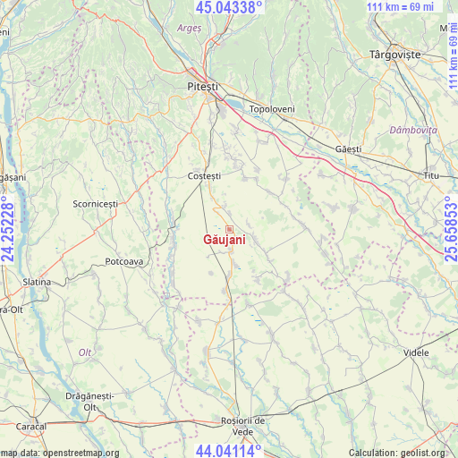
Găujani GPS coordinates[2]
44° 32' 39.912" North, 24° 57' 19.44" East
| Map corner | latitude | longitude |
|---|---|---|
| Upper-left | 45.04338°, | 24.25228° |
| Center: | 44.54442°, | 24.9554° |
| Lower-right: | 44.04114°, | 25.65853° |
| Map W x H: | 111.4×111.4 km | = 69.2×69.2mi |
| max Lat: | 48.23793° ⇑84.3% North |
| Găujani: | 44.54442° |
| min Lat: | ⇓15.7% South 43.65638° |
| min Long | Găujani | max Long |
| 20.31667° | 24.9554° | 29.65403° |
| W 46.7%⇐ | ⇒53.3% E |
Elevation
Elevation of Găujani is 202 m = 663 ft, and this is 52.9 m = 174 ft below average elevation for this country.
| Max E: |
1278 m = 4193 ft | 51.8% |
| Avg. | 254.9 m = 836 ft | |
| Găujani | 202 m = 663 ft | |
Min E: |
-2 m = -7 ft | 48.2% |
See also: Romania elevation on elevation.city.
Geographical zone
Găujani is located in North temperate zone (between Tropic of Cancer and the Arctic Circle). Distance of this Northern Tropic circle is 2347 km =1458.4 mi to South.| Distance of | km | miles | from Găujani |
|---|---|---|---|
| North Pole | 5054.2 | 3140.5 | to North |
| Arctic Circle | 2448.3 | 1521.3 | to North |
| Tropic Cancer | 2347 | 1458.4 | to South |
| Equator | 4952.9 | 3077.6 | to South |


Nearby cities:
15 places around Găujani: (largest is in red/bold)
• Burdea
11.5 km =7.1 mi,  203°
203°
• Buzoeşti
5.3 km =3.3 mi,  324°
324°
• Colțu
6 km =3.7 mi, 199°
• Cornățel
3.9 km =2.4 mi,  359°
359°
• Căldăraru
10.5 km =6.5 mi,  182°
182°
• Deagu de Sus
4.6 km =2.9 mi,  61°
61°
• Humele
2.7 km =1.7 mi,  139°
139°
• Ionești
8.6 km =5.3 mi,  330°
330°
• Izvoru
10.3 km =6.4 mi,  122°
122°
• Recea
5 km =3.1 mi,  104°
104°
• Satu Nou
8.7 km =5.4 mi,  219°
219°
• Strâmbeni
8.5 km =5.3 mi,  170°
170°
• Ungheni
5 km =3.1 mi, 169°
• Vulpești
6 km =3.7 mi,  349°
349°
• Șerboeni
11.5 km =7.1 mi, 334°
Sources, notices
• [Note1] Compared only with cities in Romania existing in our database
• [Src1] Map data: © OpenStreetMap contributors (CC-BY-SA)
• [Src2] Other city data from geonames.org with taken over terms of usage.
• [Src3] Geographical zone / Annual Mean Temperature by Robert A. Rohde @ Wikipedia
