Brazi geodata
Brazi (Hunedoara) is a populated place; located in Romania in Europe/Bucharest (GMT+3) time zone. With population of 1,277 people, there are 3569 cities with bigger population in this country. Compared to other cities in Romania, 55.5% of cities are located further ↑North; 86.7% of cities are located further →East and 88.7% of cities have lower elevation than Brazi. Note1


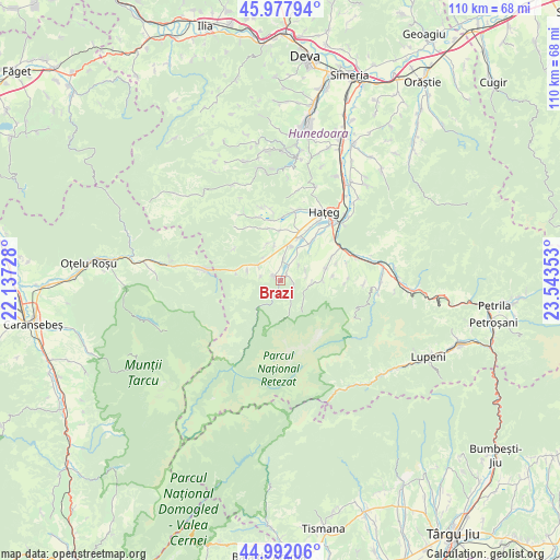
Brazi GPS coordinates[2]
45° 29' 13.776" North, 22° 50' 25.44" East
| Map corner | latitude | longitude |
|---|---|---|
| Upper-left | 45.97794°, | 22.13728° |
| Center: | 45.48716°, | 22.8404° |
| Lower-right: | 44.99206°, | 23.54353° |
| Map W x H: | 109.6×109.6 km | = 68.1×68.1mi |
| max Lat: | 48.23793° ⇑55.5% North |
| Brazi: | 45.48716° |
| min Lat: | ⇓44.5% South 43.65638° |
| min Long | Brazi | max Long |
| 20.31667° | 22.8404° | 29.65403° |
| W 13.3%⇐ | ⇒86.7% E |
Elevation
Elevation of Brazi is 492 m = 1614 ft, and this is 237.1 m = 778 ft above average elevation for this country.
| Max E: |
1278 m = 4193 ft | 11.3% |
| Brazi | 492 m 1614 ft | |
| Avg. | 254.9 m = 836 ft | |
Min E: |
-2 m = -7 ft | 88.7% |
See also: Romania elevation on elevation.city.
Geographical zone
Brazi is located in North temperate zone (between Tropic of Cancer and the Arctic Circle). Distance of this North polar circle is 2343.5 km =1456.2 mi to North.| Distance of | km | miles | from Brazi |
|---|---|---|---|
| North Pole | 4949.4 | 3075.4 | to North |
| Arctic Circle | 2343.5 | 1456.2 | to North |
| Tropic Cancer | 2451.8 | 1523.5 | to South |
| Equator | 5057.7 | 3142.7 | to South |


Nearby cities:
15 places around Brazi: (largest is in red/bold)
• Bucium-Orlea
14.5 km =9 mi,  42°
42°
• Bucova
16 km =9.9 mi,  278°
278°
• Clopotiva
1.8 km =1.1 mi,  309°
309°
• Densuş
11.1 km =6.9 mi,  343°
343°
• General Berthelot
14.8 km =9.2 mi,  13°
13°
• Peșteana
7.1 km =4.4 mi,  349°
349°
• Păclișa
8.9 km =5.5 mi,  20°
20°
• Râu de Mori
0.9 km =0.6 mi,  119°
119°
• Răchitova
14.4 km =8.9 mi,  330°
330°
• Sarmizegetusa
5.5 km =3.4 mi, 306°
• Sântămăria-Orlea
15.2 km =9.4 mi, 41°
• Săcel
10.1 km =6.3 mi, 37°
• Sălaşu de Sus
9.1 km =5.7 mi,  68°
68°
• Toteşti
9.5 km =5.9 mi, 20°
• Șerel
16.5 km =10.3 mi,  91°
91°
Sources, notices
• [Note1] Compared only with cities in Romania existing in our database
• [Src1] Map data: © OpenStreetMap contributors (CC-BY-SA)
• [Src2] Other city data from geonames.org with taken over terms of usage.
• [Src3] Geographical zone / Annual Mean Temperature by Robert A. Rohde @ Wikipedia
