Toteşti geodata
Toteşti (Hunedoara) is a seat of a second-order administrative division; located in Romania in Europe/Bucharest (GMT+3) time zone. With population of 1,990 people, there are 2611 cities with bigger population in this country. Compared to other cities in Romania, 54.1% of cities are located further ↑North; 86.2% of cities are located further →East and 77.7% of cities have lower elevation than Toteşti. Note1


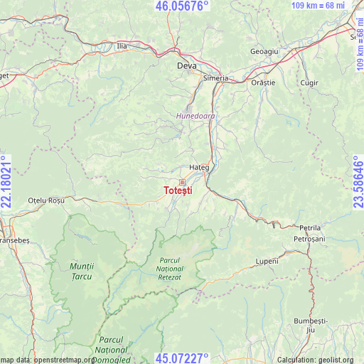
Toteşti GPS coordinates[2]
45° 34' 0.012" North, 22° 52' 59.988" East
| Map corner | latitude | longitude |
|---|---|---|
| Upper-left | 46.05676°, | 22.18021° |
| Center: | 45.56667°, | 22.88333° |
| Lower-right: | 45.07227°, | 23.58646° |
| Map W x H: | 109.5×109.5 km | = 68×68mi |
| max Lat: | 48.23793° ⇑54.1% North |
| Toteşti: | 45.56667° |
| min Lat: | ⇓45.9% South 43.65638° |
| min Long | Toteşti | max Long |
| 20.31667° | 22.88333° | 29.65403° |
| W 13.8%⇐ | ⇒86.2% E |
Elevation
Elevation of Toteşti is 373 m = 1224 ft, and this is 118.1 m = 387 ft above average elevation for this country.
| Max E: |
1278 m = 4193 ft | 22.3% |
| Toteşti | 373 m 1224 ft | |
| Avg. | 254.9 m = 836 ft | |
Min E: |
-2 m = -7 ft | 77.7% |
See also: Romania elevation on elevation.city.
Geographical zone
Toteşti is located in North temperate zone (between Tropic of Cancer and the Arctic Circle). Distance of this North polar circle is 2334.6 km =1450.7 mi to North.| Distance of | km | miles | from Toteşti |
|---|---|---|---|
| North Pole | 4940.5 | 3069.9 | to North |
| Arctic Circle | 2334.6 | 1450.7 | to North |
| Tropic Cancer | 2460.6 | 1528.9 | to South |
| Equator | 5066.5 | 3148.2 | to South |


Nearby cities:
15 places around Toteşti: (largest is in red/bold)
• Brazi
9.5 km =5.9 mi,  200°
200°
• Bucium-Orlea
6.7 km =4.2 mi,  74°
74°
• Clopotiva
9 km =5.6 mi,  211°
211°
• Densuş
6.7 km =4.2 mi,  285°
285°
• General Berthelot
5.6 km =3.5 mi,  0°
0°
• Haţeg
7.6 km =4.7 mi,  43°
43°
• Peșteana
4.9 km =3 mi,  248°
248°
• Păclișa
0.5 km =0.3 mi, 202°
• Râu de Mori
9.6 km =6 mi, 195°
• Răchitova
11 km =6.8 mi, 289°
• Sarmizegetusa
9.6 km =6 mi,  234°
234°
• Subcetate
9.8 km =6.1 mi, 65°
• Sântămăria-Orlea
7.2 km =4.5 mi, 70°
• Săcel
2.9 km =1.8 mi,  106°
106°
• Sălaşu de Sus
7.6 km =4.7 mi,  136°
136°
Sources, notices
• [Note1] Compared only with cities in Romania existing in our database
• [Src1] Map data: © OpenStreetMap contributors (CC-BY-SA)
• [Src2] Other city data from geonames.org with taken over terms of usage.
• [Src3] Geographical zone / Annual Mean Temperature by Robert A. Rohde @ Wikipedia
