Bucium-Orlea geodata
Bucium-Orlea (Hunedoara) is a populated place; located in Romania in Europe/Bucharest (GMT+3) time zone. With population of 3,485 people, there are 1434 cities with bigger population in this country. Compared to other cities in Romania, 53.9% of cities are located further ↑North; 84.9% of cities are located further →East and 70.4% of cities have lower elevation than Bucium-Orlea. Note1


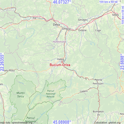
Bucium-Orlea GPS coordinates[2]
45° 34' 59.988" North, 22° 58' 0.012" East
| Map corner | latitude | longitude |
|---|---|---|
| Upper-left | 46.07327°, | 22.26355° |
| Center: | 45.58333°, | 22.96667° |
| Lower-right: | 45.08908°, | 23.6698° |
| Map W x H: | 109.4×109.4 km | = 68×68mi |
| max Lat: | 48.23793° ⇑53.9% North |
| Bucium-Orlea: | 45.58333° |
| min Lat: | ⇓46.1% South 43.65638° |
| min Long | Bucium-Orlea | max Long |
| 20.31667° | 22.96667° | 29.65403° |
| W 15.1%⇐ | ⇒84.9% E |
Elevation
Elevation of Bucium-Orlea is 324 m = 1063 ft, and this is 69.1 m = 227 ft above average elevation for this country.
| Max E: |
1278 m = 4193 ft | 29.6% |
| Bucium-Orlea | 324 m 1063 ft | |
| Avg. | 254.9 m = 836 ft | |
Min E: |
-2 m = -7 ft | 70.4% |
See also: Romania elevation on elevation.city.
Geographical zone
Bucium-Orlea is located in North temperate zone (between Tropic of Cancer and the Arctic Circle). Distance of this North polar circle is 2332.8 km =1449.5 mi to North.| Distance of | km | miles | from Bucium-Orlea |
|---|---|---|---|
| North Pole | 4938.7 | 3068.8 | to North |
| Arctic Circle | 2332.8 | 1449.5 | to North |
| Tropic Cancer | 2462.5 | 1530.1 | to South |
| Equator | 5068.4 | 3149.4 | to South |


Nearby cities:
15 places around Bucium-Orlea: (largest is in red/bold)
• Boşorod
14.3 km =8.9 mi,  39°
39°
• Bretea Română
9.5 km =5.9 mi,  24°
24°
• Densuş
13 km =8.1 mi,  270°
270°
• Fizești
10.3 km =6.4 mi,  116°
116°
• General Berthelot
7.5 km =4.7 mi,  299°
299°
• Haţeg
3.9 km =2.4 mi,  340°
340°
• Peșteana
11.7 km =7.3 mi,  251°
251°
• Pui
12.8 km =8 mi,  125°
125°
• Păclișa
7.1 km =4.4 mi, 250°
• Subcetate
3.3 km =2.1 mi,  49°
49°
• Sântămăria-Orlea
0.7 km =0.4 mi,  25°
25°
• Săcel
4.6 km =2.9 mi,  234°
234°
• Sălaşu de Sus
7.5 km =4.7 mi,  189°
189°
• Toteşti
6.7 km =4.2 mi, 254°
• Șerel
12.9 km =8 mi,  149°
149°
Sources, notices
• [Note1] Compared only with cities in Romania existing in our database
• [Src1] Map data: © OpenStreetMap contributors (CC-BY-SA)
• [Src2] Other city data from geonames.org with taken over terms of usage.
• [Src3] Geographical zone / Annual Mean Temperature by Robert A. Rohde @ Wikipedia
