Răchitova geodata
Răchitova (Hunedoara) is a seat of a second-order administrative division; located in Romania in Europe/Bucharest (GMT+3) time zone. With population of 1,467 people, there are 3232 cities with bigger population in this country. Compared to other cities in Romania, 53.6% of cities are located further ↑North; 87.7% of cities are located further →East and 89.4% of cities have lower elevation than Răchitova. Note1


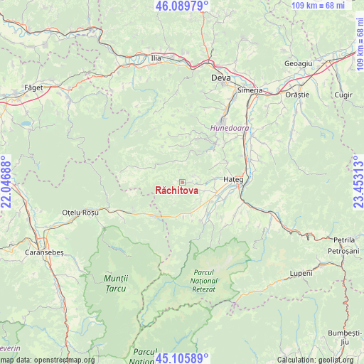
Răchitova GPS coordinates[2]
45° 36' 0" North, 22° 45' 0" East
| Map corner | latitude | longitude |
|---|---|---|
| Upper-left | 46.08979°, | 22.04688° |
| Center: | 45.6°, | 22.75° |
| Lower-right: | 45.10589°, | 23.45313° |
| Map W x H: | 109.4×109.4 km | = 68×68mi |
| max Lat: | 48.23793° ⇑53.6% North |
| Răchitova: | 45.6° |
| min Lat: | ⇓46.4% South 43.65638° |
| min Long | Răchitova | max Long |
| 20.31667° | 22.75° | 29.65403° |
| W 12.3%⇐ | ⇒87.7% E |
Elevation
Elevation of Răchitova is 504 m = 1654 ft, and this is 249.1 m = 817 ft above average elevation for this country.
| Max E: |
1278 m = 4193 ft | 10.6% |
| Răchitova | 504 m 1654 ft | |
| Avg. | 254.9 m = 836 ft | |
Min E: |
-2 m = -7 ft | 89.4% |
See also: Romania elevation on elevation.city.
Geographical zone
Răchitova is located in North temperate zone (between Tropic of Cancer and the Arctic Circle). Distance of this North polar circle is 2330.9 km =1448.4 mi to North.| Distance of | km | miles | from Răchitova |
|---|---|---|---|
| North Pole | 4936.8 | 3067.6 | to North |
| Arctic Circle | 2330.9 | 1448.4 | to North |
| Tropic Cancer | 2464.3 | 1531.2 | to South |
| Equator | 5070.2 | 3150.5 | to South |


Nearby cities:
15 places around Răchitova: (largest is in red/bold)
• Brazi
14.4 km =8.9 mi,  150°
150°
• Bucova
13.4 km =8.3 mi,  220°
220°
• Bunila
12.9 km =8 mi,  329°
329°
• Clopotiva
12.7 km =7.9 mi, 153°
• Densuş
4.3 km =2.7 mi,  115°
115°
• General Berthelot
10.5 km =6.5 mi,  79°
79°
• Ghelari
13.2 km =8.2 mi,  11°
11°
• Lunca Cernii de Jos
11 km =6.8 mi,  289°
289°
• Peșteana
8 km =5 mi,  133°
133°
• Păclișa
11 km =6.8 mi,  112°
112°
• Râu de Mori
15.1 km =9.4 mi, 149°
• Sarmizegetusa
9.6 km =6 mi,  164°
164°
• Săcel
13.9 km =8.6 mi, 109°
• Topliţa
9.6 km =6 mi,  15°
15°
• Toteşti
11 km =6.8 mi, 109°
Sources, notices
• [Note1] Compared only with cities in Romania existing in our database
• [Src1] Map data: © OpenStreetMap contributors (CC-BY-SA)
• [Src2] Other city data from geonames.org with taken over terms of usage.
• [Src3] Geographical zone / Annual Mean Temperature by Robert A. Rohde @ Wikipedia
