Bogdănești geodata
Bogdănești (Vaslui) is a seat of a second-order administrative division; located in Romania in Europe/Bucharest (GMT+3) time zone. With population of 1,014 people, there are 4249 cities with bigger population in this country. Compared to other cities in Romania, 65.8% of cities are located further ↓South; 93.5% of cities are located further ←West and 55% of cities have higher elevation than Bogdănești. Note1


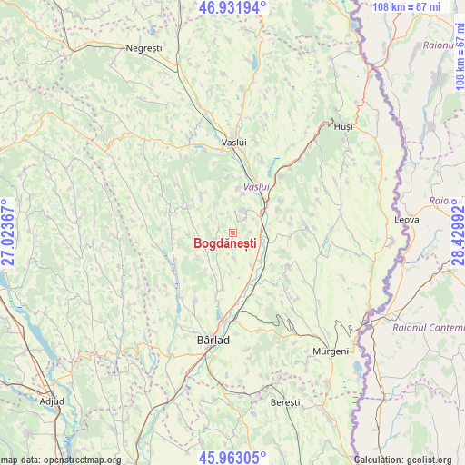
Bogdănești GPS coordinates[2]
46° 26' 58.74" North, 27° 43' 36.444" East
| Map corner | latitude | longitude |
|---|---|---|
| Upper-left | 46.93194°, | 27.02367° |
| Center: | 46.44965°, | 27.72679° |
| Lower-right: | 45.96305°, | 28.42992° |
| Map W x H: | 107.7×107.7 km | = 66.9×66.9mi |
| max Lat: | 48.23793° ⇑34.2% North |
| Bogdănești: | 46.44965° |
| min Lat: | ⇓65.8% South 43.65638° |
| min Long | Bogdănești | max Long |
| 20.31667° | 27.72679° | 29.65403° |
| W 93.5%⇐ | ⇒6.5% E |
Elevation
Elevation of Bogdănești is 187 m = 614 ft, and this is 67.9 m = 223 ft below average elevation for this country.
| Max E: |
1278 m = 4193 ft | 55% |
| Avg. | 254.9 m = 836 ft | |
| Bogdănești | 187 m = 614 ft | |
Min E: |
-2 m = -7 ft | 45% |
See also: Romania elevation on elevation.city.
Geographical zone
Bogdănești is located in North temperate zone (between Tropic of Cancer and the Arctic Circle). Distance of this North polar circle is 2236.5 km =1389.7 mi to North.| Distance of | km | miles | from Bogdănești |
|---|---|---|---|
| North Pole | 4842.3 | 3008.9 | to North |
| Arctic Circle | 2236.5 | 1389.7 | to North |
| Tropic Cancer | 2558.8 | 1590 | to South |
| Equator | 5164.7 | 3209.2 | to South |


Nearby cities:
15 places around Bogdănești: (largest is in red/bold)
• Albeşti
12.1 km =7.5 mi,  62°
62°
• Alexandru Vlăhuţă
8 km =5 mi,  242°
242°
• Bogdana
11.2 km =7 mi,  319°
319°
• Bogdăniţa
3.3 km =2.1 mi,  270°
270°
• Băcani
13.7 km =8.5 mi,  199°
199°
• Corni-Albești
13.5 km =8.4 mi, 55°
• Costeşti
5.9 km =3.7 mi,  17°
17°
• Deleni
11.3 km =7 mi,  9°
9°
• Gara Banca
13.3 km =8.3 mi,  157°
157°
• Gura Idrici
12.6 km =7.8 mi,  108°
108°
• Ibănești
9.9 km =6.2 mi,  231°
231°
• Lipovăţ
13.2 km =8.2 mi,  351°
351°
• Roşieşti
12.1 km =7.5 mi,  98°
98°
• Siliștea
13.3 km =8.3 mi,  259°
259°
• Unțești
5.8 km =3.6 mi,  176°
176°
Sources, notices
• [Note1] Compared only with cities in Romania existing in our database
• [Src1] Map data: © OpenStreetMap contributors (CC-BY-SA)
• [Src2] Other city data from geonames.org with taken over terms of usage.
• [Src3] Geographical zone / Annual Mean Temperature by Robert A. Rohde @ Wikipedia
