Alexandru Vlăhuţă geodata
Alexandru Vlăhuţă (Vaslui) is a seat of a second-order administrative division; located in Romania in Europe/Bucharest (GMT+3) time zone. With population of 3,139 people, there are 1663 cities with bigger population in this country. Compared to other cities in Romania, 65% of cities are located further ↓South; 92.5% of cities are located further ←West and 60.1% of cities have lower elevation than Alexandru Vlăhuţă. Note1


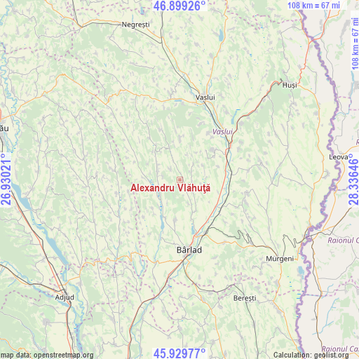
Alexandru Vlăhuţă GPS coordinates[2]
46° 25' 0.012" North, 27° 37' 59.988" East
| Map corner | latitude | longitude |
|---|---|---|
| Upper-left | 46.89926°, | 26.93021° |
| Center: | 46.41667°, | 27.63333° |
| Lower-right: | 45.92977°, | 28.33646° |
| Map W x H: | 107.8×107.8 km | = 67×67mi |
| max Lat: | 48.23793° ⇑35% North |
| Alexandru Vlăhuţă: | 46.41667° |
| min Lat: | ⇓65% South 43.65638° |
| min Long | Alexandru Vlăh | max Long |
| 20.31667° | 27.63333° | 29.65403° |
| W 92.5%⇐ | ⇒7.5% E |
Elevation
Elevation of Alexandru Vlăhuţă is 263 m = 863 ft, and this is 8.1 m = 27 ft above average elevation for this country.
| Max E: |
1278 m = 4193 ft | 39.9% |
| Alexandru Vlăhuţă | 263 m 863 ft | |
| Avg. | 254.9 m = 836 ft | |
Min E: |
-2 m = -7 ft | 60.1% |
See also: Romania elevation on elevation.city.
Geographical zone
Alexandru Vlăhuţă is located in North temperate zone (between Tropic of Cancer and the Arctic Circle). Distance of this North polar circle is 2240.1 km =1391.9 mi to North.| Distance of | km | miles | from Alexandru Vlăhuţă |
|---|---|---|---|
| North Pole | 4846 | 3011.2 | to North |
| Arctic Circle | 2240.1 | 1391.9 | to North |
| Tropic Cancer | 2555.1 | 1587.7 | to South |
| Equator | 5161 | 3206.9 | to South |


Nearby cities:
15 places around Alexandru Vlăhuţă: (largest is in red/bold)
• Bogdana
12.2 km =7.6 mi,  359°
359°
• Bogdănești
8 km =5 mi,  62°
62°
• Bogdăniţa
5.3 km =3.3 mi,  45°
45°
• Bogești
10.3 km =6.4 mi,  217°
217°
• Băcani
9.6 km =6 mi,  164°
164°
• Costeşti
12.9 km =8 mi,  43°
43°
• Hălărești
6.4 km =4 mi,  247°
247°
• Iana
7.4 km =4.6 mi,  239°
239°
• Ibănești
2.5 km =1.6 mi,  193°
193°
• Măscurei
11.9 km =7.4 mi, 224°
• Pogana
12.2 km =7.6 mi,  204°
204°
• Puieşti
10.2 km =6.3 mi,  270°
270°
• Siliștea
6 km =3.7 mi,  281°
281°
• Tomești
7.8 km =4.8 mi,  209°
209°
• Unțești
7.9 km =4.9 mi,  105°
105°
Sources, notices
• [Note1] Compared only with cities in Romania existing in our database
• [Src1] Map data: © OpenStreetMap contributors (CC-BY-SA)
• [Src2] Other city data from geonames.org with taken over terms of usage.
• [Src3] Geographical zone / Annual Mean Temperature by Robert A. Rohde @ Wikipedia
