Bârca geodata
Bârca (Dolj) is a seat of a second-order administrative division; located in Romania in Europe/Bucharest (GMT+3) time zone. With population of 4,403 people, there are 991 cities with bigger population in this country. Compared to other cities in Romania, 97.4% of cities are located further ↑North; 75.4% of cities are located further →East and 91.6% of cities have higher elevation than Bârca. Note1


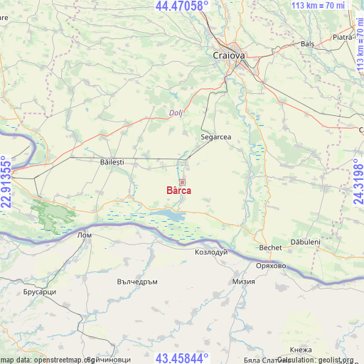
Bârca GPS coordinates[2]
43° 58' 0.012" North, 23° 37' 0.012" East
| Map corner | latitude | longitude |
|---|---|---|
| Upper-left | 44.47058°, | 22.91355° |
| Center: | 43.96667°, | 23.61667° |
| Lower-right: | 43.45844°, | 24.3198° |
| Map W x H: | 112.5×112.5 km | = 69.9×69.9mi |
| max Lat: | 48.23793° ⇑97.4% North |
| Bârca: | 43.96667° |
| min Lat: | ⇓2.6% South 43.65638° |
| min Long | Bârca | max Long |
| 20.31667° | 23.61667° | 29.65403° |
| W 24.6%⇐ | ⇒75.4% E |
Elevation
Elevation of Bârca is 50 m = 164 ft, and this is 204.9 m = 672 ft below average elevation for this country.
| Max E: |
1278 m = 4193 ft | 91.6% |
| Avg. | 254.9 m = 836 ft | |
| Bârca | 50 m = 164 ft | |
Min E: |
-2 m = -7 ft | 8.4% |
See also: Romania elevation on elevation.city.
Geographical zone
Bârca is located in North temperate zone (between Tropic of Cancer and the Arctic Circle). Distance of this Northern Tropic circle is 2282.7 km =1418.4 mi to South.| Distance of | km | miles | from Bârca |
|---|---|---|---|
| North Pole | 5118.4 | 3180.4 | to North |
| Arctic Circle | 2512.5 | 1561.2 | to North |
| Tropic Cancer | 2282.7 | 1418.4 | to South |
| Equator | 4888.6 | 3037.6 | to South |


Nearby cities:
15 places around Bârca: (largest is in red/bold)
• Afumaţi
12.6 km =7.8 mi,  287°
287°
• Bistreț
11.9 km =7.4 mi,  231°
231°
• Bistrețu Nou
13.7 km =8.5 mi,  237°
237°
• Cerăt
11.8 km =7.3 mi,  19°
19°
• Curmătura
4.4 km =2.7 mi, 23°
• Cârna
9 km =5.6 mi,  187°
187°
• Giurgiţa
5.7 km =3.5 mi,  13°
13°
• Goicea
5.6 km =3.5 mi,  180°
180°
• Lipovu
14.9 km =9.3 mi, 5°
• Măceşu de Jos
12.2 km =7.6 mi,  139°
139°
• Măceşu de Sus
8.7 km =5.4 mi,  129°
129°
• Plosca
9.4 km =5.8 mi,  212°
212°
• Siliştea Crucii
13 km =8.1 mi,  304°
304°
• Urzica Mare
5.7 km =3.5 mi,  344°
344°
• Urzicuţa
7.7 km =4.8 mi,  316°
316°
Sources, notices
• [Note1] Compared only with cities in Romania existing in our database
• [Src1] Map data: © OpenStreetMap contributors (CC-BY-SA)
• [Src2] Other city data from geonames.org with taken over terms of usage.
• [Src3] Geographical zone / Annual Mean Temperature by Robert A. Rohde @ Wikipedia
