Lipovu geodata
Lipovu (Dolj) is a seat of a second-order administrative division; located in Romania in Europe/Bucharest (GMT+3) time zone. With population of 3,152 people, there are 1655 cities with bigger population in this country. Compared to other cities in Romania, 95.5% of cities are located further ↑North; 75.2% of cities are located further →East and 87.6% of cities have higher elevation than Lipovu. Note1


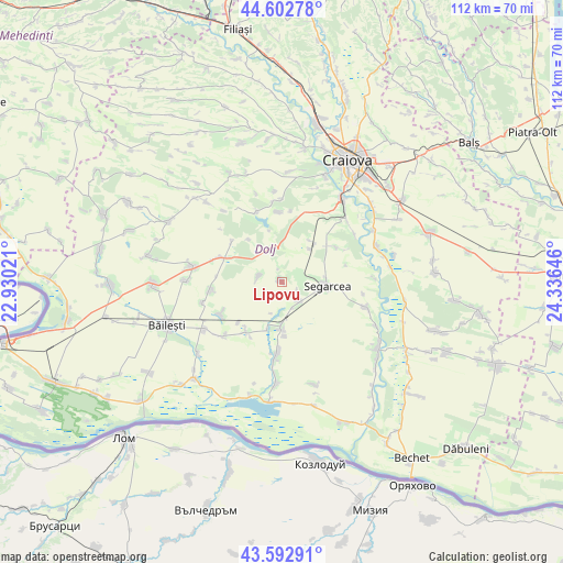
Lipovu GPS coordinates[2]
44° 6' 0" North, 23° 37' 59.988" East
| Map corner | latitude | longitude |
|---|---|---|
| Upper-left | 44.60278°, | 22.93021° |
| Center: | 44.1°, | 23.63333° |
| Lower-right: | 43.59291°, | 24.33646° |
| Map W x H: | 112.3×112.3 km | = 69.8×69.8mi |
| max Lat: | 48.23793° ⇑95.5% North |
| Lipovu: | 44.1° |
| min Lat: | ⇓4.5% South 43.65638° |
| min Long | Lipovu | max Long |
| 20.31667° | 23.63333° | 29.65403° |
| W 24.8%⇐ | ⇒75.2% E |
Elevation
Elevation of Lipovu is 69 m = 226 ft, and this is 185.9 m = 610 ft below average elevation for this country.
| Max E: |
1278 m = 4193 ft | 87.6% |
| Avg. | 254.9 m = 836 ft | |
| Lipovu | 69 m = 226 ft | |
Min E: |
-2 m = -7 ft | 12.4% |
See also: Romania elevation on elevation.city.
Geographical zone
Lipovu is located in North temperate zone (between Tropic of Cancer and the Arctic Circle). Distance of this Northern Tropic circle is 2297.5 km =1427.6 mi to South.| Distance of | km | miles | from Lipovu |
|---|---|---|---|
| North Pole | 5103.6 | 3171.2 | to North |
| Arctic Circle | 2497.7 | 1552 | to North |
| Tropic Cancer | 2297.5 | 1427.6 | to South |
| Equator | 4903.5 | 3046.9 | to South |


Nearby cities:
15 places around Lipovu: (largest is in red/bold)
• Belcinu
13.2 km =8.2 mi,  75°
75°
• Calopăr
12.5 km =7.8 mi,  54°
54°
• Cerăt
4.6 km =2.9 mi,  144°
144°
• Curmătura
10.8 km =6.7 mi,  177°
177°
• Giurgiţa
9.3 km =5.8 mi, 180°
• Panaghia
10 km =6.2 mi,  34°
34°
• Perișor
13.5 km =8.4 mi,  290°
290°
• Radovan
7.5 km =4.7 mi,  349°
349°
• Satu Nou Calopăr
13 km =8.1 mi,  55°
55°
• Segarcea
9.3 km =5.8 mi,  90°
90°
• Sălcuța
8.6 km =5.3 mi,  39°
39°
• Urzica Mare
9.8 km =6.1 mi,  197°
197°
• Urzicuţa
11.4 km =7.1 mi,  215°
215°
• Vârvor
13.9 km =8.6 mi,  356°
356°
• Întorsura
4.8 km =3 mi, 286°
Sources, notices
• [Note1] Compared only with cities in Romania existing in our database
• [Src1] Map data: © OpenStreetMap contributors (CC-BY-SA)
• [Src2] Other city data from geonames.org with taken over terms of usage.
• [Src3] Geographical zone / Annual Mean Temperature by Robert A. Rohde @ Wikipedia
