Siliştea Crucii geodata
Siliştea Crucii (Dolj) is a seat of a second-order administrative division; located in Romania in Europe/Bucharest (GMT+3) time zone. With population of 1,826 people, there are 2792 cities with bigger population in this country. Compared to other cities in Romania, 96.5% of cities are located further ↑North; 77.3% of cities are located further →East and 91.3% of cities have higher elevation than Siliştea Crucii. Note1


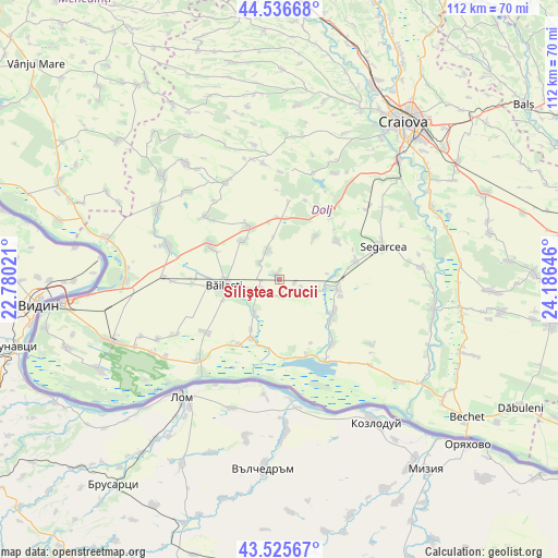
Siliştea Crucii GPS coordinates[2]
44° 1' 59.988" North, 23° 28' 59.988" East
| Map corner | latitude | longitude |
|---|---|---|
| Upper-left | 44.53668°, | 22.78021° |
| Center: | 44.03333°, | 23.48333° |
| Lower-right: | 43.52567°, | 24.18646° |
| Map W x H: | 112.4×112.4 km | = 69.8×69.8mi |
| max Lat: | 48.23793° ⇑96.5% North |
| Siliştea Crucii: | 44.03333° |
| min Lat: | ⇓3.5% South 43.65638° |
| min Long | Siliştea Cruci | max Long |
| 20.31667° | 23.48333° | 29.65403° |
| W 22.7%⇐ | ⇒77.3% E |
Elevation
Elevation of Siliştea Crucii is 52 m = 171 ft, and this is 202.9 m = 666 ft below average elevation for this country.
| Max E: |
1278 m = 4193 ft | 91.3% |
| Avg. | 254.9 m = 836 ft | |
| Siliştea Crucii | 52 m = 171 ft | |
Min E: |
-2 m = -7 ft | 8.7% |
See also: Romania elevation on elevation.city.
Geographical zone
Siliştea Crucii is located in North temperate zone (between Tropic of Cancer and the Arctic Circle). Distance of this Northern Tropic circle is 2290.1 km =1423 mi to South.| Distance of | km | miles | from Siliştea Crucii |
|---|---|---|---|
| North Pole | 5111 | 3175.8 | to North |
| Arctic Circle | 2505.1 | 1556.6 | to North |
| Tropic Cancer | 2290.1 | 1423 | to South |
| Equator | 4896 | 3042.2 | to South |


Nearby cities:
15 places around Siliştea Crucii: (largest is in red/bold)
• Afumaţi
3.9 km =2.4 mi,  199°
199°
• Boureni
4.4 km =2.7 mi,  243°
243°
• Bârca
13 km =8.1 mi,  124°
124°
• Băileşti
10.8 km =6.7 mi,  260°
260°
• Cioroiași
6.2 km =3.9 mi,  334°
334°
• Cioroiu Nou
5.2 km =3.2 mi,  310°
310°
• Covei
8.2 km =5.1 mi,  216°
216°
• Curmătura
12.9 km =8 mi,  105°
105°
• Galiciuica
10.7 km =6.6 mi,  316°
316°
• Giubega
12.1 km =7.5 mi, 329°
• Giurgiţa
12.1 km =7.5 mi,  98°
98°
• Perișor
12.2 km =7.6 mi,  356°
356°
• Urzica Mare
9.3 km =5.8 mi, 101°
• Urzicuţa
5.6 km =3.5 mi, 109°
• Întorsura
11.5 km =7.1 mi,  40°
40°
Sources, notices
• [Note1] Compared only with cities in Romania existing in our database
• [Src1] Map data: © OpenStreetMap contributors (CC-BY-SA)
• [Src2] Other city data from geonames.org with taken over terms of usage.
• [Src3] Geographical zone / Annual Mean Temperature by Robert A. Rohde @ Wikipedia
