Biled geodata
Biled (Timiş) is a seat of a second-order administrative division; located in Romania in Europe/Bucharest (GMT+3) time zone. With population of 6,230 people, there are 506 cities with bigger population in this country. Compared to other cities in Romania, 52.4% of cities are located further ↓South; 99.3% of cities are located further →East and 81.6% of cities have higher elevation than Biled. Note1


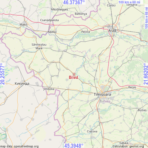
Biled GPS coordinates[2]
45° 53' 11.004" North, 20° 57' 32.004" East
| Map corner | latitude | longitude |
|---|---|---|
| Upper-left | 46.37367°, | 20.25577° |
| Center: | 45.88639°, | 20.95889° |
| Lower-right: | 45.3948°, | 21.66202° |
| Map W x H: | 108.8×108.8 km | = 67.6×67.6mi |
| max Lat: | 48.23793° ⇑47.6% North |
| Biled: | 45.88639° |
| min Lat: | ⇓52.4% South 43.65638° |
| min Long | Biled | max Long |
| 20.31667° | 20.95889° | 29.65403° |
| W 0.7%⇐ | ⇒99.3% E |
Elevation
Elevation of Biled is 89 m = 292 ft, and this is 165.9 m = 544 ft below average elevation for this country.
| Max E: |
1278 m = 4193 ft | 81.6% |
| Avg. | 254.9 m = 836 ft | |
| Biled | 89 m = 292 ft | |
Min E: |
-2 m = -7 ft | 18.4% |
See also: Romania elevation on elevation.city.
Geographical zone
Biled is located in North temperate zone (between Tropic of Cancer and the Arctic Circle). Distance of this North polar circle is 2299.1 km =1428.6 mi to North.| Distance of | km | miles | from Biled |
|---|---|---|---|
| North Pole | 4905 | 3047.8 | to North |
| Arctic Circle | 2299.1 | 1428.6 | to North |
| Tropic Cancer | 2496.2 | 1551.1 | to South |
| Equator | 5102.1 | 3170.3 | to South |


Nearby cities:
15 places around Biled: (largest is in red/bold)
• Becicherecu Mic
9.6 km =6 mi,  131°
131°
• Beregsău Mare
15.1 km =9.4 mi,  159°
159°
• Beregsău Mic
15.1 km =9.4 mi,  174°
174°
• Bulgăruș
11.2 km =7 mi,  289°
289°
• Bărăteaz
14.1 km =8.8 mi,  48°
48°
• Cărpiniş
11.8 km =7.3 mi,  201°
201°
• Dudeștii Noi
12.2 km =7.6 mi,  114°
114°
• Hodoni
10.3 km =6.4 mi,  77°
77°
• Iecea Mare
6.5 km =4 mi,  232°
232°
• Iecea Mică
7.7 km =4.8 mi, 200°
• Lenauheim
12.4 km =7.7 mi,  262°
262°
• Satchinez
8.5 km =5.3 mi, 48°
• Uihei
8 km =5 mi, 290°
• Variaş
14.5 km =9 mi,  357°
357°
• Şandra
6.8 km =4.2 mi,  308°
308°
Sources, notices
• [Note1] Compared only with cities in Romania existing in our database
• [Src1] Map data: © OpenStreetMap contributors (CC-BY-SA)
• [Src2] Other city data from geonames.org with taken over terms of usage.
• [Src3] Geographical zone / Annual Mean Temperature by Robert A. Rohde @ Wikipedia
