Bulgăruș geodata
Bulgăruș (Timiş) is a populated place; located in Romania in Europe/Bucharest (GMT+3) time zone. With population of 1,754 people, there are 2869 cities with bigger population in this country. Compared to other cities in Romania, 53.3% of cities are located further ↓South; 99.7% of cities are located further →East and 82.2% of cities have higher elevation than Bulgăruș. Note1


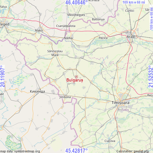
Bulgăruș GPS coordinates[2]
45° 55' 10.092" North, 20° 49' 19.884" East
| Map corner | latitude | longitude |
|---|---|---|
| Upper-left | 46.40646°, | 20.11907° |
| Center: | 45.91947°, | 20.82219° |
| Lower-right: | 45.42817°, | 21.52532° |
| Map W x H: | 108.8×108.8 km | = 67.6×67.6mi |
| max Lat: | 48.23793° ⇑46.7% North |
| Bulgăruș: | 45.91947° |
| min Lat: | ⇓53.3% South 43.65638° |
| min Long | Bulgăruș | max Long |
| 20.31667° | 20.82219° | 29.65403° |
| W 0.3%⇐ | ⇒99.7% E |
Elevation
Elevation of Bulgăruș is 87 m = 285 ft, and this is 167.9 m = 551 ft below average elevation for this country.
| Max E: |
1278 m = 4193 ft | 82.2% |
| Avg. | 254.9 m = 836 ft | |
| Bulgăruș | 87 m = 285 ft | |
Min E: |
-2 m = -7 ft | 17.8% |
See also: Romania elevation on elevation.city.
Geographical zone
Bulgăruș is located in North temperate zone (between Tropic of Cancer and the Arctic Circle). Distance of this North polar circle is 2295.4 km =1426.3 mi to North.| Distance of | km | miles | from Bulgăruș |
|---|---|---|---|
| North Pole | 4901.3 | 3045.5 | to North |
| Arctic Circle | 2295.4 | 1426.3 | to North |
| Tropic Cancer | 2499.8 | 1553.3 | to South |
| Equator | 5105.8 | 3172.6 | to South |


Nearby cities:
15 places around Bulgăruș: (largest is in red/bold)
• Biled
11.2 km =7 mi,  109°
109°
• Comloșu Mic
14.1 km =8.8 mi,  237°
237°
• Gottlob
8.7 km =5.4 mi,  282°
282°
• Grabăț
7.7 km =4.8 mi,  233°
233°
• Iecea Mare
9.4 km =5.8 mi,  144°
144°
• Iecea Mică
13.4 km =8.3 mi, 144°
• Lenauheim
5.6 km =3.5 mi,  198°
198°
• Lovrin
6.7 km =4.2 mi,  323°
323°
• Periam
14.9 km =9.3 mi,  13°
13°
• Pesac
8.6 km =5.3 mi, 6°
• Sânpetru Mare
14 km =8.7 mi,  358°
358°
• Tomnatic
14.6 km =9.1 mi,  301°
301°
• Uihei
3.2 km =2 mi, 105°
• Variaş
14.6 km =9.1 mi,  42°
42°
• Şandra
5.3 km =3.3 mi,  83°
83°
Sources, notices
• [Note1] Compared only with cities in Romania existing in our database
• [Src1] Map data: © OpenStreetMap contributors (CC-BY-SA)
• [Src2] Other city data from geonames.org with taken over terms of usage.
• [Src3] Geographical zone / Annual Mean Temperature by Robert A. Rohde @ Wikipedia
