Bengești geodata
Bengești (Gorj) is a seat of a second-order administrative division; located in Romania in Europe/Bucharest (GMT+3) time zone. With population of 1,416 people, there are 3312 cities with bigger population in this country. Compared to other cities in Romania, 67.1% of cities are located further ↑North; 75.6% of cities are located further →East and 64.2% of cities have lower elevation than Bengești. Note1


Bengești GPS coordinates[2]
45° 4' 0.012" North, 23° 36' 0" East
| Map corner | latitude | longitude |
|---|---|---|
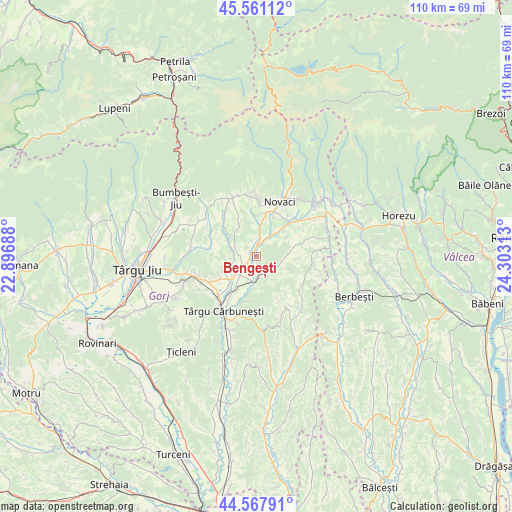
| Upper-left | 45.56112°, | 22.89688° |
| Center: | 45.06667°, | 23.6° |
| Lower-right: | 44.56791°, | 24.30313° |
| Map W x H: | 110.4×110.4 km | = 68.6×68.6mi |
| max Lat: | 48.23793° ⇑67.1% North |
| Bengești: | 45.06667° |
| min Lat: | ⇓32.9% South 43.65638° |
| min Long | Bengești | max Long |
| 20.31667° | 23.6° | 29.65403° |
| W 24.4%⇐ | ⇒75.6% E |
Elevation
Elevation of Bengești is 285 m = 935 ft, and this is 30.1 m = 99 ft above average elevation for this country.
| Max E: |
1278 m = 4193 ft | 35.8% |
| Bengești | 285 m 935 ft | |
| Avg. | 254.9 m = 836 ft | |
Min E: |
-2 m = -7 ft | 64.2% |
See also: Romania elevation on elevation.city.
Geographical zone
Bengești is located in North temperate zone (between Tropic of Cancer and the Arctic Circle). Distance of this North polar circle is 2390.2 km =1485.2 mi to North.| Distance of | km | miles | from Bengești |
|---|---|---|---|
| North Pole | 4996.1 | 3104.4 | to North |
| Arctic Circle | 2390.2 | 1485.2 | to North |
| Tropic Cancer | 2405 | 1494.4 | to South |
| Equator | 5010.9 | 3113.6 | to South |


Nearby cities:
15 places around Bengești: (largest is in red/bold)
• Albeni
3.7 km =2.3 mi,  180°
180°
• Blahnița de Sus
8.6 km =5.3 mi,  333°
333°
• Bobu
7.9 km =4.9 mi,  243°
243°
• Bolbocești
6.7 km =4.2 mi, 183°
• Bucșana
9 km =5.6 mi,  91°
91°
• Bumbești-Pițic
9.7 km =6 mi,  44°
44°
• Bălcești
5 km =3.1 mi,  31°
31°
• Ciocadia
5.7 km =3.5 mi,  7°
7°
• Cârligei
8 km =5 mi,  57°
57°
• Călugăreasa
4.3 km =2.7 mi,  130°
130°
• Magherești
6.7 km =4.2 mi,  296°
296°
• Prigoria
6.5 km =4 mi, 90°
• Săcelu
6.4 km =4 mi,  305°
305°
• Zorlești
9.8 km =6.1 mi,  73°
73°
• Ștefănești
9.9 km =6.2 mi,  195°
195°
Sources, notices
• [Note1] Compared only with cities in Romania existing in our database
• [Src1] Map data: © OpenStreetMap contributors (CC-BY-SA)
• [Src2] Other city data from geonames.org with taken over terms of usage.
• [Src3] Geographical zone / Annual Mean Temperature by Robert A. Rohde @ Wikipedia
