Bacova geodata
Bacova (Timiş) is a populated place; located in Romania in Europe/Bucharest (GMT+3) time zone. With population of 1,424 people, there are 3301 cities with bigger population in this country. Compared to other cities in Romania, 52.6% of cities are located further ↑North; 97.4% of cities are located further →East and 73.6% of cities have higher elevation than Bacova. Note1


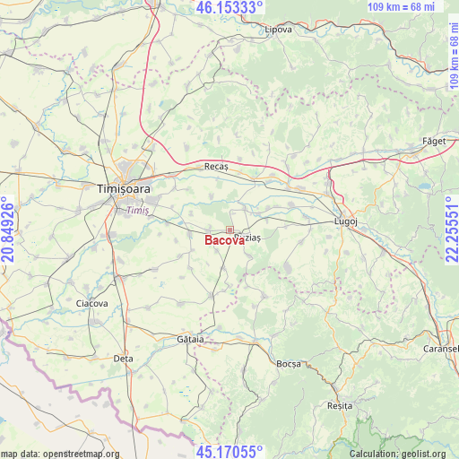
Bacova GPS coordinates[2]
45° 39' 50.76" North, 21° 33' 8.568" East
| Map corner | latitude | longitude |
|---|---|---|
| Upper-left | 46.15333°, | 20.84926° |
| Center: | 45.6641°, | 21.55238° |
| Lower-right: | 45.17055°, | 22.25551° |
| Map W x H: | 109.3×109.3 km | = 67.9×67.9mi |
| max Lat: | 48.23793° ⇑52.6% North |
| Bacova: | 45.6641° |
| min Lat: | ⇓47.4% South 43.65638° |
| min Long | Bacova | max Long |
| 20.31667° | 21.55238° | 29.65403° |
| W 2.6%⇐ | ⇒97.4% E |
Elevation
Elevation of Bacova is 115 m = 377 ft, and this is 139.9 m = 459 ft below average elevation for this country.
| Max E: |
1278 m = 4193 ft | 73.6% |
| Avg. | 254.9 m = 836 ft | |
| Bacova | 115 m = 377 ft | |
Min E: |
-2 m = -7 ft | 26.4% |
See also: Romania elevation on elevation.city.
Geographical zone
Bacova is located in North temperate zone (between Tropic of Cancer and the Arctic Circle). Distance of this North polar circle is 2323.8 km =1443.9 mi to North.| Distance of | km | miles | from Bacova |
|---|---|---|---|
| North Pole | 4929.7 | 3063.2 | to North |
| Arctic Circle | 2323.8 | 1443.9 | to North |
| Tropic Cancer | 2471.5 | 1535.7 | to South |
| Equator | 5077.4 | 3154.9 | to South |


Nearby cities:
15 places around Bacova: (largest is in red/bold)
• Bazoș
9.2 km =5.7 mi,  331°
331°
• Buziaş
4.3 km =2.7 mi,  112°
112°
• Chevereşu Mare
4.8 km =3 mi,  273°
273°
• Hitiaș
6.3 km =3.9 mi,  34°
34°
• Iosifalău
16.5 km =10.3 mi,  37°
37°
• Niţchidorf
9.1 km =5.7 mi,  189°
189°
• Ohaba-Forgaci
15.9 km =9.9 mi,  67°
67°
• Racoviţa
7.5 km =4.7 mi,  59°
59°
• Recaş
15.5 km =9.6 mi,  345°
345°
• Sacoşu Turcesc
9.7 km =6 mi,  261°
261°
• Sacoșu Mare
16.3 km =10.1 mi,  122°
122°
• Silagiu
7.7 km =4.8 mi,  143°
143°
• Sinersig
13.3 km =8.3 mi,  85°
85°
• Topolovăţu Mare
13.3 km =8.3 mi,  22°
22°
• Uliuc
15 km =9.3 mi,  275°
275°
Sources, notices
• [Note1] Compared only with cities in Romania existing in our database
• [Src1] Map data: © OpenStreetMap contributors (CC-BY-SA)
• [Src2] Other city data from geonames.org with taken over terms of usage.
• [Src3] Geographical zone / Annual Mean Temperature by Robert A. Rohde @ Wikipedia
