Racoviţa geodata
Racoviţa (Timiş) is a seat of a second-order administrative division; located in Romania in Europe/Bucharest (GMT+3) time zone. With population of 3,260 people, there are 1582 cities with bigger population in this country. Compared to other cities in Romania, 52.1% of cities are located further ↑North; 96.8% of cities are located further →East and 78% of cities have higher elevation than Racoviţa. Note1


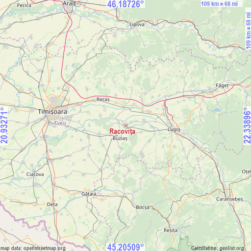
Racoviţa GPS coordinates[2]
45° 41' 53.988" North, 21° 38' 8.988" East
| Map corner | latitude | longitude |
|---|---|---|
| Upper-left | 46.18726°, | 20.93271° |
| Center: | 45.69833°, | 21.63583° |
| Lower-right: | 45.20509°, | 22.33896° |
| Map W x H: | 109.2×109.2 km | = 67.9×67.9mi |
| max Lat: | 48.23793° ⇑52.1% North |
| Racoviţa: | 45.69833° |
| min Lat: | ⇓47.9% South 43.65638° |
| min Long | Racoviţa | max Long |
| 20.31667° | 21.63583° | 29.65403° |
| W 3.2%⇐ | ⇒96.8% E |
Elevation
Elevation of Racoviţa is 101 m = 331 ft, and this is 153.9 m = 505 ft below average elevation for this country.
| Max E: |
1278 m = 4193 ft | 78% |
| Avg. | 254.9 m = 836 ft | |
| Racoviţa | 101 m = 331 ft | |
Min E: |
-2 m = -7 ft | 22% |
See also: Romania elevation on elevation.city.
Geographical zone
Racoviţa is located in North temperate zone (between Tropic of Cancer and the Arctic Circle). Distance of this North polar circle is 2320 km =1441.6 mi to North.| Distance of | km | miles | from Racoviţa |
|---|---|---|---|
| North Pole | 4925.9 | 3060.8 | to North |
| Arctic Circle | 2320 | 1441.6 | to North |
| Tropic Cancer | 2475.3 | 1538.1 | to South |
| Equator | 5081.2 | 3157.3 | to South |


Nearby cities:
15 places around Racoviţa: (largest is in red/bold)
• Bacova
7.5 km =4.7 mi,  239°
239°
• Bazoș
11.6 km =7.2 mi,  291°
291°
• Belinţ
11.5 km =7.1 mi,  56°
56°
• Boldur
10.9 km =6.8 mi,  92°
92°
• Buziaş
6 km =3.7 mi,  204°
204°
• Chevereşu Mare
11.8 km =7.3 mi,  252°
252°
• Chizătău
9.7 km =6 mi,  50°
50°
• Darova
12.4 km =7.7 mi,  120°
120°
• Darova Nouă
12.5 km =7.8 mi,  125°
125°
• Hitiaș
3.2 km =2 mi,  295°
295°
• Iosifalău
9.9 km =6.2 mi,  20°
20°
• Ohaba-Forgaci
8.5 km =5.3 mi,  74°
74°
• Silagiu
10.2 km =6.3 mi,  190°
190°
• Sinersig
7.3 km =4.5 mi,  112°
112°
• Topolovăţu Mare
8.5 km =5.3 mi,  351°
351°
Sources, notices
• [Note1] Compared only with cities in Romania existing in our database
• [Src1] Map data: © OpenStreetMap contributors (CC-BY-SA)
• [Src2] Other city data from geonames.org with taken over terms of usage.
• [Src3] Geographical zone / Annual Mean Temperature by Robert A. Rohde @ Wikipedia
