Topolovăţu Mare geodata
Topolovăţu Mare (Timiş) is a seat of a second-order administrative division; located in Romania in Europe/Bucharest (GMT+3) time zone. With population of 2,942 people, there are 1823 cities with bigger population in this country. Compared to other cities in Romania, 50.3% of cities are located further ↑North; 96.9% of cities are located further →East and 77.4% of cities have higher elevation than Topolovăţu Mare. Note1


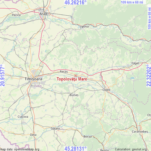
Topolovăţu Mare GPS coordinates[2]
45° 46' 26.004" North, 21° 37' 8.004" East
| Map corner | latitude | longitude |
|---|---|---|
| Upper-left | 46.26216°, | 20.91577° |
| Center: | 45.77389°, | 21.61889° |
| Lower-right: | 45.28131°, | 22.32202° |
| Map W x H: | 109.1×109.1 km | = 67.8×67.8mi |
| max Lat: | 48.23793° ⇑50.3% North |
| Topolovăţu Mare: | 45.77389° |
| min Lat: | ⇓49.7% South 43.65638° |
| min Long | Topolovăţu Ma | max Long |
| 20.31667° | 21.61889° | 29.65403° |
| W 3.1%⇐ | ⇒96.9% E |
Elevation
Elevation of Topolovăţu Mare is 103 m = 338 ft, and this is 151.9 m = 498 ft below average elevation for this country.
| Max E: |
1278 m = 4193 ft | 77.4% |
| Avg. | 254.9 m = 836 ft | |
| Topolovăţu Mare | 103 m = 338 ft | |
Min E: |
-2 m = -7 ft | 22.6% |
See also: Romania elevation on elevation.city.
Geographical zone
Topolovăţu Mare is located in North temperate zone (between Tropic of Cancer and the Arctic Circle). Distance of this North polar circle is 2311.6 km =1436.4 mi to North.| Distance of | km | miles | from Topolovăţu Mare |
|---|---|---|---|
| North Pole | 4917.5 | 3055.6 | to North |
| Arctic Circle | 2311.6 | 1436.4 | to North |
| Tropic Cancer | 2483.7 | 1543.3 | to South |
| Equator | 5089.6 | 3162.5 | to South |


Nearby cities:
15 places around Topolovăţu Mare: (largest is in red/bold)
• Bacova
13.3 km =8.3 mi,  202°
202°
• Bazoș
10.4 km =6.5 mi,  246°
246°
• Belinţ
11.2 km =7 mi,  100°
100°
• Brestovăț
12.1 km =7.5 mi,  23°
23°
• Buziaş
13.9 km =8.6 mi,  184°
184°
• Chizătău
9.1 km =5.7 mi, 104°
• Ghizela
10.7 km =6.6 mi,  58°
58°
• Hitiaș
7.2 km =4.5 mi,  192°
192°
• Iosifalău
4.9 km =3 mi,  79°
79°
• Izvin
12.6 km =7.8 mi,  283°
283°
• Ohaba-Forgaci
11.3 km =7 mi,  122°
122°
• Racoviţa
8.5 km =5.3 mi,  171°
171°
• Recaş
9.6 km =6 mi,  286°
286°
• Sinersig
13.8 km =8.6 mi,  144°
144°
• Șanovița
9.1 km =5.7 mi,  72°
72°
Sources, notices
• [Note1] Compared only with cities in Romania existing in our database
• [Src1] Map data: © OpenStreetMap contributors (CC-BY-SA)
• [Src2] Other city data from geonames.org with taken over terms of usage.
• [Src3] Geographical zone / Annual Mean Temperature by Robert A. Rohde @ Wikipedia
