Atid geodata
Atid (Harghita) is a seat of a second-order administrative division; located in Romania in Europe/Bucharest (GMT+3) time zone. With population of 2,797 people, there are 1913 cities with bigger population in this country. Compared to other cities in Romania, 65.8% of cities are located further ↓South; 52% of cities are located further →East and 84.6% of cities have lower elevation than Atid. Note1


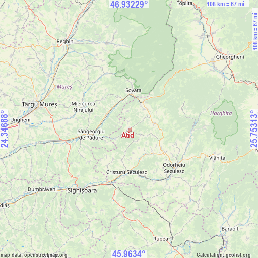
Atid GPS coordinates[2]
46° 27' 0" North, 25° 3' 0" East
| Map corner | latitude | longitude |
|---|---|---|
| Upper-left | 46.93229°, | 24.34688° |
| Center: | 46.45°, | 25.05° |
| Lower-right: | 45.9634°, | 25.75313° |
| Map W x H: | 107.7×107.7 km | = 66.9×66.9mi |
| max Lat: | 48.23793° ⇑34.2% North |
| Atid: | 46.45° |
| min Lat: | ⇓65.8% South 43.65638° |
| min Long | Atid | max Long |
| 20.31667° | 25.05° | 29.65403° |
| W 48%⇐ | ⇒52% E |
Elevation
Elevation of Atid is 442 m = 1450 ft, and this is 187.1 m = 614 ft above average elevation for this country.
| Max E: |
1278 m = 4193 ft | 15.4% |
| Atid | 442 m 1450 ft | |
| Avg. | 254.9 m = 836 ft | |
Min E: |
-2 m = -7 ft | 84.6% |
See also: Romania elevation on elevation.city.
Geographical zone
Atid is located in North temperate zone (between Tropic of Cancer and the Arctic Circle). Distance of this North polar circle is 2236.4 km =1389.6 mi to North.| Distance of | km | miles | from Atid |
|---|---|---|---|
| North Pole | 4842.3 | 3008.9 | to North |
| Arctic Circle | 2236.4 | 1389.6 | to North |
| Tropic Cancer | 2558.8 | 1590 | to South |
| Equator | 5164.8 | 3209.3 | to South |


Nearby cities:
15 places around Atid: (largest is in red/bold)
• Avrămeşti
13.2 km =8.2 mi,  191°
191°
• Bezid
10.8 km =6.7 mi,  242°
242°
• Chibed
11.4 km =7.1 mi,  324°
324°
• Corund
10.4 km =6.5 mi,  79°
79°
• Crișeni
7 km =4.3 mi, 237°
• Ghindari
11.6 km =7.2 mi,  298°
298°
• Goagiu
9.5 km =5.9 mi, 189°
• Lupeni
14.8 km =9.2 mi,  120°
120°
• Ocna de Jos
10.4 km =6.5 mi,  35°
35°
• Ocna de Sus
11.6 km =7.2 mi, 42°
• Praid
12.8 km =8 mi,  29°
29°
• Simoneşti
13.5 km =8.4 mi,  163°
163°
• Sărățeni
12.8 km =8 mi,  347°
347°
• Trei Sate
11.9 km =7.4 mi,  283°
283°
• Șoimușu Mic
14.4 km =8.9 mi,  208°
208°
Sources, notices
• [Note1] Compared only with cities in Romania existing in our database
• [Src1] Map data: © OpenStreetMap contributors (CC-BY-SA)
• [Src2] Other city data from geonames.org with taken over terms of usage.
• [Src3] Geographical zone / Annual Mean Temperature by Robert A. Rohde @ Wikipedia
