Praid geodata
Praid (Harghita) is a seat of a second-order administrative division; located in Romania in Europe/Bucharest (GMT+3) time zone. With population of 6,739 people, there are 437 cities with bigger population in this country. Compared to other cities in Romania, 68.1% of cities are located further ↓South; 51% of cities are located further →East and 90.9% of cities have lower elevation than Praid. Note1


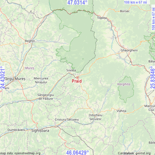
Praid GPS coordinates[2]
46° 33' 0" North, 25° 7' 59.988" East
| Map corner | latitude | longitude |
|---|---|---|
| Upper-left | 47.0314°, | 24.43021° |
| Center: | 46.55°, | 25.13333° |
| Lower-right: | 46.06429°, | 25.83646° |
| Map W x H: | 107.5×107.5 km | = 66.8×66.8mi |
| max Lat: | 48.23793° ⇑31.9% North |
| Praid: | 46.55° |
| min Lat: | ⇓68.1% South 43.65638° |
| min Long | Praid | max Long |
| 20.31667° | 25.13333° | 29.65403° |
| W 49%⇐ | ⇒51% E |
Elevation
Elevation of Praid is 527 m = 1729 ft, and this is 272.1 m = 893 ft above average elevation for this country.
| Max E: |
1278 m = 4193 ft | 9.1% |
| Praid | 527 m 1729 ft | |
| Avg. | 254.9 m = 836 ft | |
Min E: |
-2 m = -7 ft | 90.9% |
See also: Romania elevation on elevation.city.
Geographical zone
Praid is located in North temperate zone (between Tropic of Cancer and the Arctic Circle). Distance of this North polar circle is 2225.3 km =1382.7 mi to North.| Distance of | km | miles | from Praid |
|---|---|---|---|
| North Pole | 4831.2 | 3002 | to North |
| Arctic Circle | 2225.3 | 1382.7 | to North |
| Tropic Cancer | 2570 | 1596.9 | to South |
| Equator | 5175.9 | 3216.2 | to South |


Nearby cities:
15 places around Praid: (largest is in red/bold)
• Atid
12.8 km =8 mi,  209°
209°
• Chibed
13.2 km =8.2 mi,  261°
261°
• Corund
10 km =6.2 mi,  157°
157°
• Crișeni
19.3 km =12 mi,  219°
219°
• Ghindari
17.5 km =10.9 mi,  251°
251°
• Lupeni
19.6 km =12.2 mi, 160°
• Măgherani
17.9 km =11.1 mi,  275°
275°
• Ocna de Jos
2.6 km =1.6 mi,  186°
186°
• Ocna de Sus
2.9 km =1.8 mi,  151°
151°
• Sovata
6.3 km =3.9 mi,  306°
306°
• Săcădat
9.9 km =6.2 mi,  326°
326°
• Sărățeni
9.3 km =5.8 mi, 278°
• Trei Sate
19.8 km =12.3 mi, 245°
• Vărşag
17 km =10.6 mi,  102°
102°
• Șilea Nirajului
17 km =10.6 mi,  288°
288°
Sources, notices
• [Note1] Compared only with cities in Romania existing in our database
• [Src1] Map data: © OpenStreetMap contributors (CC-BY-SA)
• [Src2] Other city data from geonames.org with taken over terms of usage.
• [Src3] Geographical zone / Annual Mean Temperature by Robert A. Rohde @ Wikipedia
