Argetoaia geodata
Argetoaia (Dolj) is a seat of a second-order administrative division; located in Romania in Europe/Bucharest (GMT+3) time zone. With population of 4,862 people, there are 828 cities with bigger population in this country. Compared to other cities in Romania, 84.9% of cities are located further ↑North; 78.9% of cities are located further →East and 62.1% of cities have higher elevation than Argetoaia. Note1


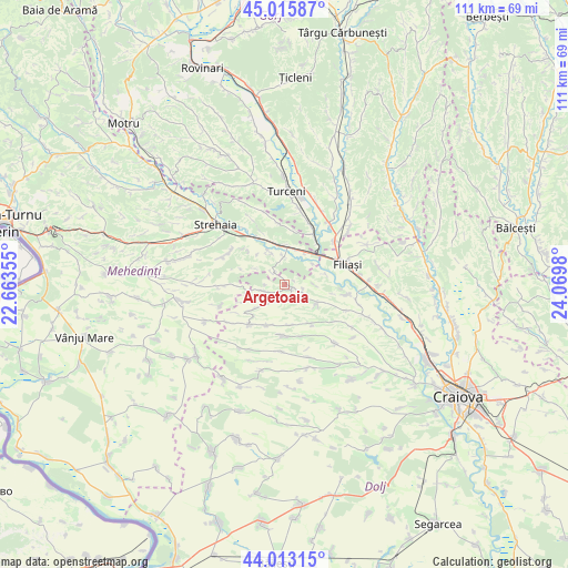
Argetoaia GPS coordinates[2]
44° 31' 0.012" North, 23° 22' 0.012" East
| Map corner | latitude | longitude |
|---|---|---|
| Upper-left | 45.01587°, | 22.66355° |
| Center: | 44.51667°, | 23.36667° |
| Lower-right: | 44.01315°, | 24.0698° |
| Map W x H: | 111.5×111.5 km | = 69.3×69.3mi |
| max Lat: | 48.23793° ⇑84.9% North |
| Argetoaia: | 44.51667° |
| min Lat: | ⇓15.1% South 43.65638° |
| min Long | Argetoaia | max Long |
| 20.31667° | 23.36667° | 29.65403° |
| W 21.1%⇐ | ⇒78.9% E |
Elevation
Elevation of Argetoaia is 158 m = 518 ft, and this is 96.9 m = 318 ft below average elevation for this country.
| Max E: |
1278 m = 4193 ft | 62.1% |
| Avg. | 254.9 m = 836 ft | |
| Argetoaia | 158 m = 518 ft | |
Min E: |
-2 m = -7 ft | 37.9% |
See also: Romania elevation on elevation.city.
Geographical zone
Argetoaia is located in North temperate zone (between Tropic of Cancer and the Arctic Circle). Distance of this Northern Tropic circle is 2343.9 km =1456.4 mi to South.| Distance of | km | miles | from Argetoaia |
|---|---|---|---|
| North Pole | 5057.3 | 3142.5 | to North |
| Arctic Circle | 2451.4 | 1523.2 | to North |
| Tropic Cancer | 2343.9 | 1456.4 | to South |
| Equator | 4949.8 | 3075.7 | to South |


Nearby cities:
15 places around Argetoaia: (largest is in red/bold)
• Arginești
7.4 km =4.6 mi,  30°
30°
• Braloştiţa
12 km =7.5 mi,  98°
98°
• Buicești
5.4 km =3.4 mi,  357°
357°
• Butoieşti
7.4 km =4.6 mi,  0°
0°
• Bâlta
8.5 km =5.3 mi,  75°
75°
• Bărboi
8.6 km =5.3 mi,  204°
204°
• Cernăteşti
9.1 km =5.7 mi,  144°
144°
• Gogoşu
11.1 km =6.9 mi,  180°
180°
• Greceşti
9.9 km =6.2 mi,  221°
221°
• Pluta
7.1 km =4.4 mi,  335°
335°
• Salcia
7.4 km =4.6 mi,  121°
121°
• Secu
7.7 km =4.8 mi, 223°
• Stângăceaua
11.1 km =6.9 mi, 337°
• Valea Fântânilor
9.5 km =5.9 mi, 100°
• Țiu
8 km =5 mi,  170°
170°
Sources, notices
• [Note1] Compared only with cities in Romania existing in our database
• [Src1] Map data: © OpenStreetMap contributors (CC-BY-SA)
• [Src2] Other city data from geonames.org with taken over terms of usage.
• [Src3] Geographical zone / Annual Mean Temperature by Robert A. Rohde @ Wikipedia
