Buicești geodata
Buicești (Mehedinţi) is a populated place; located in Romania in Europe/Bucharest (GMT+3) time zone. With population of 573 people, there are 6403 cities with bigger population in this country. Compared to other cities in Romania, 83.9% of cities are located further ↑North; 79% of cities are located further →East and 65.7% of cities have higher elevation than Buicești. Note1


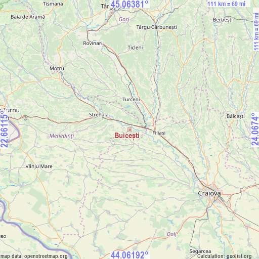
Buicești GPS coordinates[2]
44° 33' 54.072" North, 23° 21' 51.372" East
| Map corner | latitude | longitude |
|---|---|---|
| Upper-left | 45.06381°, | 22.66115° |
| Center: | 44.56502°, | 23.36427° |
| Lower-right: | 44.06192°, | 24.0674° |
| Map W x H: | 111.4×111.4 km | = 69.2×69.2mi |
| max Lat: | 48.23793° ⇑83.9% North |
| Buicești: | 44.56502° |
| min Lat: | ⇓16.1% South 43.65638° |
| min Long | Buicești | max Long |
| 20.31667° | 23.36427° | 29.65403° |
| W 21%⇐ | ⇒79% E |
Elevation
Elevation of Buicești is 144 m = 472 ft, and this is 110.9 m = 364 ft below average elevation for this country.
| Max E: |
1278 m = 4193 ft | 65.7% |
| Avg. | 254.9 m = 836 ft | |
| Buicești | 144 m = 472 ft | |
Min E: |
-2 m = -7 ft | 34.3% |
See also: Romania elevation on elevation.city.
Geographical zone
Buicești is located in North temperate zone (between Tropic of Cancer and the Arctic Circle). Distance of this Northern Tropic circle is 2349.2 km =1459.7 mi to South.| Distance of | km | miles | from Buicești |
|---|---|---|---|
| North Pole | 5051.9 | 3139.1 | to North |
| Arctic Circle | 2446 | 1519.9 | to North |
| Tropic Cancer | 2349.2 | 1459.7 | to South |
| Equator | 4955.2 | 3079 | to South |


Nearby cities:
15 places around Buicești: (largest is in red/bold)
• Argetoaia
5.4 km =3.4 mi,  177°
177°
• Arginești
4.1 km =2.5 mi,  76°
76°
• Brezniţa-Motru
11.7 km =7.3 mi,  270°
270°
• Butoieşti
2 km =1.2 mi,  5°
5°
• Bâlta
9 km =5.6 mi,  111°
111°
• Capu Dealului
11.5 km =7.1 mi,  51°
51°
• Grozeşti
10.2 km =6.3 mi,  338°
338°
• Iliești
9.2 km =5.7 mi,  18°
18°
• Ioneşti
7.9 km =4.9 mi,  43°
43°
• Lunca Banului
10.9 km =6.8 mi,  300°
300°
• Pluta
2.9 km =1.8 mi,  292°
292°
• Salcia
11.3 km =7 mi,  144°
144°
• Stângăceaua
6.4 km =4 mi,  320°
320°
• Valea Fântânilor
11.8 km =7.3 mi,  126°
126°
• Ţânţăreni
10.2 km =6.3 mi,  67°
67°
Sources, notices
• [Note1] Compared only with cities in Romania existing in our database
• [Src1] Map data: © OpenStreetMap contributors (CC-BY-SA)
• [Src2] Other city data from geonames.org with taken over terms of usage.
• [Src3] Geographical zone / Annual Mean Temperature by Robert A. Rohde @ Wikipedia
