Amărăști geodata
Amărăști (Dolj) is a populated place; located in Romania in Europe/Bucharest (GMT+3) time zone. With population of 601 people, there are 6200 cities with bigger population in this country. Compared to other cities in Romania, 83.1% of cities are located further ↑North; 73.8% of cities are located further →East and 59.2% of cities have higher elevation than Amărăști. Note1


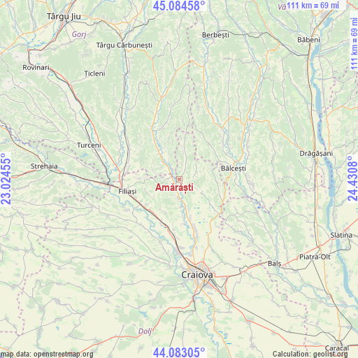
Amărăști GPS coordinates[2]
44° 35' 9.492" North, 23° 43' 39.612" East
| Map corner | latitude | longitude |
|---|---|---|
| Upper-left | 45.08458°, | 23.02455° |
| Center: | 44.58597°, | 23.72767° |
| Lower-right: | 44.08305°, | 24.4308° |
| Map W x H: | 111.4×111.4 km | = 69.2×69.2mi |
| max Lat: | 48.23793° ⇑83.1% North |
| Amărăști: | 44.58597° |
| min Lat: | ⇓16.9% South 43.65638° |
| min Long | Amărăști | max Long |
| 20.31667° | 23.72767° | 29.65403° |
| W 26.2%⇐ | ⇒73.8% E |
Elevation
Elevation of Amărăști is 169 m = 554 ft, and this is 85.9 m = 282 ft below average elevation for this country.
| Max E: |
1278 m = 4193 ft | 59.2% |
| Avg. | 254.9 m = 836 ft | |
| Amărăști | 169 m = 554 ft | |
Min E: |
-2 m = -7 ft | 40.8% |
See also: Romania elevation on elevation.city.
Geographical zone
Amărăști is located in North temperate zone (between Tropic of Cancer and the Arctic Circle). Distance of this Northern Tropic circle is 2351.6 km =1461.2 mi to South.| Distance of | km | miles | from Amărăști |
|---|---|---|---|
| North Pole | 5049.6 | 3137.7 | to North |
| Arctic Circle | 2443.7 | 1518.4 | to North |
| Tropic Cancer | 2351.6 | 1461.2 | to South |
| Equator | 4957.5 | 3080.4 | to South |


Nearby cities:
15 places around Amărăști: (largest is in red/bold)
• Brădeşti
13.6 km =8.5 mi,  213°
213°
• Bulzeşti
13.7 km =8.5 mi,  115°
115°
• Crușeț
7.1 km =4.4 mi,  317°
317°
• Fratoștița
12.5 km =7.8 mi,  270°
270°
• Fărcaș
2.4 km =1.5 mi,  48°
48°
• Goiești
11.8 km =7.3 mi,  164°
164°
• Golumbu
5.7 km =3.5 mi,  21°
21°
• Melineşti
2.3 km =1.4 mi,  202°
202°
• Măiag
8.8 km =5.5 mi,  289°
289°
• Negoiești
5.6 km =3.5 mi,  180°
180°
• Slăvuța
13 km =8.1 mi,  344°
344°
• Stoina
13.1 km =8.1 mi,  325°
325°
• Tatomirești
12.9 km =8 mi,  233°
233°
• Tălpaș
10.8 km =6.7 mi,  7°
7°
• Velesti
5.1 km =3.2 mi,  71°
71°
Sources, notices
• [Note1] Compared only with cities in Romania existing in our database
• [Src1] Map data: © OpenStreetMap contributors (CC-BY-SA)
• [Src2] Other city data from geonames.org with taken over terms of usage.
• [Src3] Geographical zone / Annual Mean Temperature by Robert A. Rohde @ Wikipedia
