Alunișu geodata
Alunișu (Ilfov) is a populated place; located in Romania in Europe/Bucharest (GMT+3) time zone. With population of 1,245 people, there are 3647 cities with bigger population in this country. Compared to other cities in Romania, 89.9% of cities are located further ↑North; 64.2% of cities are located further ←West and 86.5% of cities have higher elevation than Alunișu. Note1


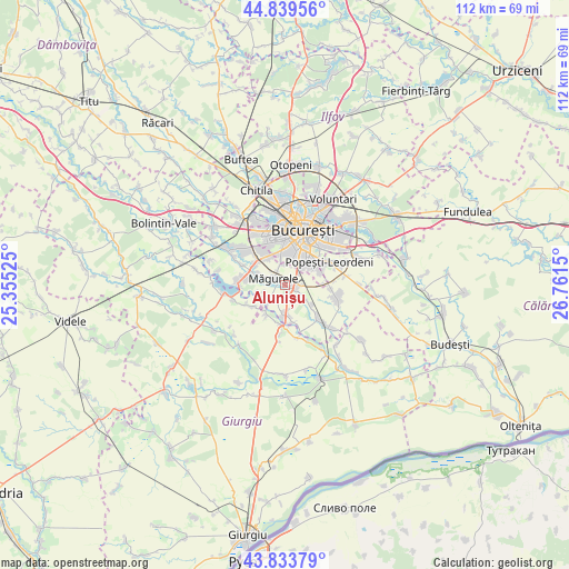
Alunișu GPS coordinates[2]
44° 20' 19.788" North, 26° 3' 30.132" East
| Map corner | latitude | longitude |
|---|---|---|
| Upper-left | 44.83956°, | 25.35525° |
| Center: | 44.33883°, | 26.05837° |
| Lower-right: | 43.83379°, | 26.7615° |
| Map W x H: | 111.8×111.8 km | = 69.5×69.5mi |
| max Lat: | 48.23793° ⇑89.9% North |
| Alunișu: | 44.33883° |
| min Lat: | ⇓10.1% South 43.65638° |
| min Long | Alunișu | max Long |
| 20.31667° | 26.05837° | 29.65403° |
| W 64.2%⇐ | ⇒35.8% E |
Elevation
Elevation of Alunișu is 73 m = 240 ft, and this is 181.9 m = 597 ft below average elevation for this country.
| Max E: |
1278 m = 4193 ft | 86.5% |
| Avg. | 254.9 m = 836 ft | |
| Alunișu | 73 m = 240 ft | |
Min E: |
-2 m = -7 ft | 13.5% |
See also: Romania elevation on elevation.city.
Geographical zone
Alunișu is located in North temperate zone (between Tropic of Cancer and the Arctic Circle). Distance of this Northern Tropic circle is 2324.1 km =1444.1 mi to South.| Distance of | km | miles | from Alunișu |
|---|---|---|---|
| North Pole | 5077 | 3154.7 | to North |
| Arctic Circle | 2471.2 | 1535.5 | to North |
| Tropic Cancer | 2324.1 | 1444.1 | to South |
| Equator | 4930 | 3063.4 | to South |


Nearby cities:
15 places around Alunișu: (largest is in red/bold)
• 1 Decembrie
5.3 km =3.3 mi,  180°
180°
• Bragadiru
7.4 km =4.6 mi,  299°
299°
• Copăceni
8.9 km =5.5 mi,  161°
161°
• Crețești
8.8 km =5.5 mi,  135°
135°
• Dumitrana
5 km =3.1 mi,  249°
249°
• Dărăşti-Ilfov
4.6 km =2.9 mi,  223°
223°
• Dărăști-Vlașca
6.2 km =3.9 mi, 216°
• Jilava
1.7 km =1.1 mi,  111°
111°
• Măgurele
2.3 km =1.4 mi, 301°
• Novaci
7.1 km =4.4 mi,  233°
233°
• Popești
8.4 km =5.2 mi,  243°
243°
• Sector 4
6.4 km =4 mi,  50°
50°
• Sector 5
5.6 km =3.5 mi,  10°
10°
• Sintești
6.6 km =4.1 mi,  130°
130°
• Vârteju
5.6 km =3.5 mi,  289°
289°
Sources, notices
• [Note1] Compared only with cities in Romania existing in our database
• [Src1] Map data: © OpenStreetMap contributors (CC-BY-SA)
• [Src2] Other city data from geonames.org with taken over terms of usage.
• [Src3] Geographical zone / Annual Mean Temperature by Robert A. Rohde @ Wikipedia
