Bragadiru geodata
Bragadiru (Ilfov) is a seat of a second-order administrative division; located in Romania in Europe/Bucharest (GMT+3) time zone. With population of 8,274 people, there are 291 cities with bigger population in this country. Compared to other cities in Romania, 89% of cities are located further ↑North; 62.4% of cities are located further ←West and 83.8% of cities have higher elevation than Bragadiru. Note1


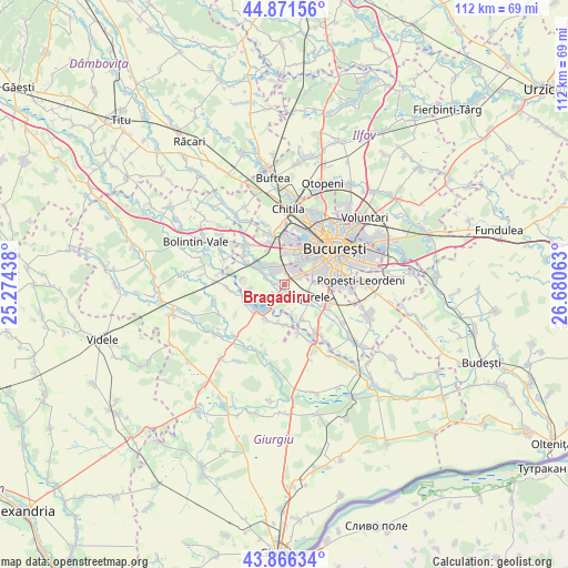
Bragadiru GPS coordinates[2]
44° 22' 15.996" North, 25° 58' 39" East
| Map corner | latitude | longitude |
|---|---|---|
| Upper-left | 44.87156°, | 25.27438° |
| Center: | 44.37111°, | 25.9775° |
| Lower-right: | 43.86634°, | 26.68063° |
| Map W x H: | 111.8×111.8 km | = 69.5×69.5mi |
| max Lat: | 48.23793° ⇑89% North |
| Bragadiru: | 44.37111° |
| min Lat: | ⇓11% South 43.65638° |
| min Long | Bragadiru | max Long |
| 20.31667° | 25.9775° | 29.65403° |
| W 62.4%⇐ | ⇒37.6% E |
Elevation
Elevation of Bragadiru is 82 m = 269 ft, and this is 172.9 m = 567 ft below average elevation for this country.
| Max E: |
1278 m = 4193 ft | 83.8% |
| Avg. | 254.9 m = 836 ft | |
| Bragadiru | 82 m = 269 ft | |
Min E: |
-2 m = -7 ft | 16.2% |
See also: Romania elevation on elevation.city.
Geographical zone
Bragadiru is located in North temperate zone (between Tropic of Cancer and the Arctic Circle). Distance of this Northern Tropic circle is 2327.7 km =1446.4 mi to South.| Distance of | km | miles | from Bragadiru |
|---|---|---|---|
| North Pole | 5073.5 | 3152.5 | to North |
| Arctic Circle | 2467.6 | 1533.3 | to North |
| Tropic Cancer | 2327.7 | 1446.4 | to South |
| Equator | 4933.6 | 3065.6 | to South |


Nearby cities:
15 places around Bragadiru: (largest is in red/bold)
• Alunișu
7.4 km =4.6 mi,  119°
119°
• Clinceni
1.8 km =1.1 mi,  277°
277°
• Cornetu
4.4 km =2.7 mi,  221°
221°
• Domneşti-Sârbi
5 km =3.1 mi,  285°
285°
• Domnești
5.8 km =3.6 mi,  302°
302°
• Dumitrana
5.6 km =3.5 mi,  162°
162°
• Dărăşti-Ilfov
7.6 km =4.7 mi,  154°
154°
• Mihăileşti
7.4 km =4.6 mi,  228°
228°
• Măgurele
5 km =3.1 mi, 117°
• Novaci
7.8 km =4.8 mi,  174°
174°
• Olteni
3.3 km =2.1 mi,  318°
318°
• Popești
7.5 km =4.7 mi,  188°
188°
• Sector 5
7.7 km =4.8 mi,  75°
75°
• Sector 6
7.8 km =4.8 mi,  23°
23°
• Vârteju
2 km =1.2 mi, 145°
Sources, notices
• [Note1] Compared only with cities in Romania existing in our database
• [Src1] Map data: © OpenStreetMap contributors (CC-BY-SA)
• [Src2] Other city data from geonames.org with taken over terms of usage.
• [Src3] Geographical zone / Annual Mean Temperature by Robert A. Rohde @ Wikipedia
