Sector 5 geodata
Sector 5 (Bucureşti) is a section of populated place; located in Romania in Europe/Bucharest (GMT+3) time zone. With population of 271,575 people, there are 12 cities with bigger population in this country. Compared to other cities in Romania, 88.5% of cities are located further ↑North; 64.5% of cities are located further ←West and 84.2% of cities have higher elevation than Sector 5. Note1


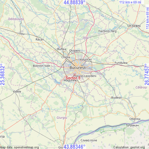
Sector 5 GPS coordinates[2]
44° 23' 17.088" North, 26° 4' 17.184" East
| Map corner | latitude | longitude |
|---|---|---|
| Upper-left | 44.88839°, | 25.36832° |
| Center: | 44.38808°, | 26.07144° |
| Lower-right: | 43.88346°, | 26.77457° |
| Map W x H: | 111.7×111.7 km | = 69.4×69.4mi |
| max Lat: | 48.23793° ⇑88.5% North |
| Sector 5: | 44.38808° |
| min Lat: | ⇓11.5% South 43.65638° |
| min Long | Sector 5 | max Long |
| 20.31667° | 26.07144° | 29.65403° |
| W 64.5%⇐ | ⇒35.5% E |
Elevation
Elevation of Sector 5 is 81 m = 266 ft, and this is 173.9 m = 571 ft below average elevation for this country.
| Max E: |
1278 m = 4193 ft | 84.2% |
| Avg. | 254.9 m = 836 ft | |
| Sector 5 | 81 m = 266 ft | |
Min E: |
-2 m = -7 ft | 15.8% |
See also: Sector 5 elevation on elevation.city.
Geographical zone
Sector 5 is located in North temperate zone (between Tropic of Cancer and the Arctic Circle). Distance of this Northern Tropic circle is 2329.6 km =1447.5 mi to South.| Distance of | km | miles | from Sector 5 |
|---|---|---|---|
| North Pole | 5071.6 | 3151.3 | to North |
| Arctic Circle | 2465.7 | 1532.1 | to North |
| Tropic Cancer | 2329.6 | 1447.5 | to South |
| Equator | 4935.5 | 3066.8 | to South |


Nearby cities:
15 places around Sector 5: (largest is in red/bold)
• Alunișu
5.6 km =3.5 mi,  190°
190°
• Bragadiru
7.7 km =4.8 mi,  255°
255°
• Bucharest
5.6 km =3.5 mi,  29°
29°
• Bucuresti
4.9 km =3 mi,  24°
24°
• Clinceni
9.4 km =5.8 mi, 259°
• Dumitrana
9.3 km =5.8 mi,  218°
218°
• Jilava
6.1 km =3.8 mi,  175°
175°
• Măgurele
5.2 km =3.2 mi, 215°
• Popeşti-Leordeni
7.6 km =4.7 mi,  93°
93°
• Roșu
8.4 km =5.2 mi,  325°
325°
• Sector 2
8.7 km =5.4 mi, 34°
• Sector 3
8.7 km =5.4 mi,  63°
63°
• Sector 4
4.2 km =2.6 mi,  109°
109°
• Sector 6
6.9 km =4.3 mi,  320°
320°
• Vârteju
7.3 km =4.5 mi,  240°
240°
Sources, notices
• [Note1] Compared only with cities in Romania existing in our database
• [Src1] Map data: © OpenStreetMap contributors (CC-BY-SA)
• [Src2] Other city data from geonames.org with taken over terms of usage.
• [Src3] Geographical zone / Annual Mean Temperature by Robert A. Rohde @ Wikipedia
