Almăjel geodata
Almăjel (Mehedinţi) is a populated place; located in Romania in Europe/Bucharest (GMT+3) time zone. With population of 939 people, there are 4490 cities with bigger population in this country. Compared to other cities in Romania, 88.7% of cities are located further ↑North; 84% of cities are located further →East and 56.9% of cities have lower elevation than Almăjel. Note1


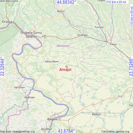
Almăjel GPS coordinates[2]
44° 22' 59.052" North, 23° 1' 46.416" East
| Map corner | latitude | longitude |
|---|---|---|
| Upper-left | 44.88342°, | 22.32644° |
| Center: | 44.38307°, | 23.02956° |
| Lower-right: | 43.8784°, | 23.73269° |
| Map W x H: | 111.7×111.7 km | = 69.4×69.4mi |
| max Lat: | 48.23793° ⇑88.7% North |
| Almăjel: | 44.38307° |
| min Lat: | ⇓11.3% South 43.65638° |
| min Long | Almăjel | max Long |
| 20.31667° | 23.02956° | 29.65403° |
| W 16%⇐ | ⇒84% E |
Elevation
Elevation of Almăjel is 247 m = 810 ft, and this is 7.9 m = 26 ft below average elevation for this country.
| Max E: |
1278 m = 4193 ft | 43.1% |
| Avg. | 254.9 m = 836 ft | |
| Almăjel | 247 m = 810 ft | |
Min E: |
-2 m = -7 ft | 56.9% |
See also: Romania elevation on elevation.city.
Geographical zone
Almăjel is located in North temperate zone (between Tropic of Cancer and the Arctic Circle). Distance of this Northern Tropic circle is 2329 km =1447.2 mi to South.| Distance of | km | miles | from Almăjel |
|---|---|---|---|
| North Pole | 5072.1 | 3151.7 | to North |
| Arctic Circle | 2466.2 | 1532.4 | to North |
| Tropic Cancer | 2329 | 1447.2 | to South |
| Equator | 4934.9 | 3066.4 | to South |


Nearby cities:
15 places around Almăjel: (largest is in red/bold)
• Bălăciţa
8.2 km =5.1 mi,  89°
89°
• Corlăţel
7.9 km =4.9 mi,  282°
282°
• Dobra
4.9 km =3 mi,  80°
80°
• Drincea
9.1 km =5.7 mi,  195°
195°
• Gvardinița
9.4 km =5.8 mi, 81°
• Iablanița
9.7 km =6 mi,  340°
340°
• Oprişor
11.9 km =7.4 mi,  158°
158°
• Orevița Mare
12.4 km =7.7 mi,  311°
311°
• Padina Mică
5.7 km =3.5 mi,  329°
329°
• Prisăceaua
8.9 km =5.5 mi,  144°
144°
• Recea
11.4 km =7.1 mi,  231°
231°
• Slașoma
4.4 km =2.7 mi,  21°
21°
• Stignița
12.4 km =7.7 mi,  349°
349°
• Valea Anilor
8.7 km =5.4 mi,  256°
256°
• Vlădaia
3.7 km =2.3 mi,  175°
175°
Sources, notices
• [Note1] Compared only with cities in Romania existing in our database
• [Src1] Map data: © OpenStreetMap contributors (CC-BY-SA)
• [Src2] Other city data from geonames.org with taken over terms of usage.
• [Src3] Geographical zone / Annual Mean Temperature by Robert A. Rohde @ Wikipedia
