Stignița geodata
Stignița (Mehedinţi) is a populated place; located in Romania in Europe/Bucharest (GMT+3) time zone. With population of 668 people, there are 5759 cities with bigger population in this country. Compared to other cities in Romania, 85.4% of cities are located further ↑North; 84.4% of cities are located further →East and 54.1% of cities have lower elevation than Stignița. Note1


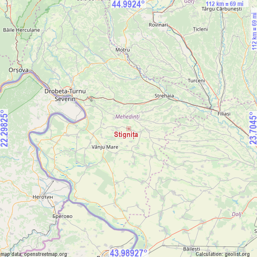
Stignița GPS coordinates[2]
44° 29' 34.764" North, 23° 0' 4.932" East
| Map corner | latitude | longitude |
|---|---|---|
| Upper-left | 44.9924°, | 22.29825° |
| Center: | 44.49299°, | 23.00137° |
| Lower-right: | 43.98927°, | 23.7045° |
| Map W x H: | 111.5×111.5 km | = 69.3×69.3mi |
| max Lat: | 48.23793° ⇑85.4% North |
| Stignița: | 44.49299° |
| min Lat: | ⇓14.6% South 43.65638° |
| min Long | Stignița | max Long |
| 20.31667° | 23.00137° | 29.65403° |
| W 15.6%⇐ | ⇒84.4% E |
Elevation
Elevation of Stignița is 234 m = 768 ft, and this is 20.9 m = 69 ft below average elevation for this country.
| Max E: |
1278 m = 4193 ft | 45.9% |
| Avg. | 254.9 m = 836 ft | |
| Stignița | 234 m = 768 ft | |
Min E: |
-2 m = -7 ft | 54.1% |
See also: Romania elevation on elevation.city.
Geographical zone
Stignița is located in North temperate zone (between Tropic of Cancer and the Arctic Circle). Distance of this Northern Tropic circle is 2341.2 km =1454.8 mi to South.| Distance of | km | miles | from Stignița |
|---|---|---|---|
| North Pole | 5059.9 | 3144.1 | to North |
| Arctic Circle | 2454 | 1524.8 | to North |
| Tropic Cancer | 2341.2 | 1454.8 | to South |
| Equator | 4947.2 | 3074 | to South |


Nearby cities:
15 places around Stignița: (largest is in red/bold)
• Almăjel
12.4 km =7.7 mi,  169°
169°
• Bâcleș
10.5 km =6.5 mi,  95°
95°
• Corlăţel
11.8 km =7.3 mi,  207°
207°
• Dumbrava de Sus
9.5 km =5.9 mi,  73°
73°
• Greci
11.1 km =6.9 mi,  55°
55°
• Iablanița
3.3 km =2.1 mi,  197°
197°
• Livezile
11.2 km =7 mi,  281°
281°
• Orevița Mare
8.1 km =5 mi,  240°
240°
• Padina Mică
7.3 km =4.5 mi,  185°
185°
• Poroina Mare
5.2 km =3.2 mi,  272°
272°
• Slașoma
9 km =5.6 mi,  154°
154°
• Traian
12 km =7.5 mi,  251°
251°
• Tâmna
8.3 km =5.2 mi,  8°
8°
• Valea Ursului
11.6 km =7.2 mi,  21°
21°
• Vânju-Mare
12.9 km =8 mi,  234°
234°
Sources, notices
• [Note1] Compared only with cities in Romania existing in our database
• [Src1] Map data: © OpenStreetMap contributors (CC-BY-SA)
• [Src2] Other city data from geonames.org with taken over terms of usage.
• [Src3] Geographical zone / Annual Mean Temperature by Robert A. Rohde @ Wikipedia
