Slașoma geodata
Slașoma (Mehedinţi) is a populated place; located in Romania in Europe/Bucharest (GMT+3) time zone. With population of 800 people, there are 5046 cities with bigger population in this country. Compared to other cities in Romania, 87.6% of cities are located further ↑North; 83.8% of cities are located further →East and 50.7% of cities have higher elevation than Slașoma. Note1


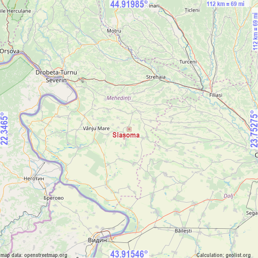
Slașoma GPS coordinates[2]
44° 25' 11.316" North, 23° 2' 58.632" East
| Map corner | latitude | longitude |
|---|---|---|
| Upper-left | 44.91985°, | 22.3465° |
| Center: | 44.41981°, | 23.04962° |
| Lower-right: | 43.91546°, | 23.75275° |
| Map W x H: | 111.7×111.7 km | = 69.4×69.4mi |
| max Lat: | 48.23793° ⇑87.6% North |
| Slașoma: | 44.41981° |
| min Lat: | ⇓12.4% South 43.65638° |
| min Long | Slașoma | max Long |
| 20.31667° | 23.04962° | 29.65403° |
| W 16.2%⇐ | ⇒83.8% E |
Elevation
Elevation of Slașoma is 208 m = 682 ft, and this is 46.9 m = 154 ft below average elevation for this country.
| Max E: |
1278 m = 4193 ft | 50.7% |
| Avg. | 254.9 m = 836 ft | |
| Slașoma | 208 m = 682 ft | |
Min E: |
-2 m = -7 ft | 49.3% |
See also: Romania elevation on elevation.city.
Geographical zone
Slașoma is located in North temperate zone (between Tropic of Cancer and the Arctic Circle). Distance of this Northern Tropic circle is 2333.1 km =1449.7 mi to South.| Distance of | km | miles | from Slașoma |
|---|---|---|---|
| North Pole | 5068 | 3149.1 | to North |
| Arctic Circle | 2462.2 | 1529.9 | to North |
| Tropic Cancer | 2333.1 | 1449.7 | to South |
| Equator | 4939 | 3069 | to South |


Nearby cities:
15 places around Slașoma: (largest is in red/bold)
• Almăjel
4.4 km =2.7 mi,  201°
201°
• Bâcleș
9.7 km =6 mi,  43°
43°
• Bălăciţa
7.8 km =4.8 mi,  121°
121°
• Corlăţel
9.6 km =6 mi,  255°
255°
• Corzu
10.2 km =6.3 mi,  68°
68°
• Dobra
4.6 km =2.9 mi,  134°
134°
• Dumbrava de Sus
12 km =7.5 mi,  26°
26°
• Gvardinița
8.2 km =5.1 mi,  109°
109°
• Iablanița
7 km =4.3 mi,  315°
315°
• Orevița Mare
11.6 km =7.2 mi,  290°
290°
• Padina Mică
4.6 km =2.9 mi,  280°
280°
• Prisăceaua
11.9 km =7.4 mi,  162°
162°
• Stignița
9 km =5.6 mi,  334°
334°
• Valea Anilor
11.8 km =7.3 mi,  238°
238°
• Vlădaia
7.9 km =4.9 mi,  189°
189°
Sources, notices
• [Note1] Compared only with cities in Romania existing in our database
• [Src1] Map data: © OpenStreetMap contributors (CC-BY-SA)
• [Src2] Other city data from geonames.org with taken over terms of usage.
• [Src3] Geographical zone / Annual Mean Temperature by Robert A. Rohde @ Wikipedia
