Afumaţi geodata
Afumaţi (Ilfov) is a seat of a second-order administrative division; located in Romania in Europe/Bucharest (GMT+3) time zone. With population of 6,696 people, there are 442 cities with bigger population in this country. Compared to other cities in Romania, 84.9% of cities are located further ↑North; 68.1% of cities are located further ←West and 84.7% of cities have higher elevation than Afumaţi. Note1


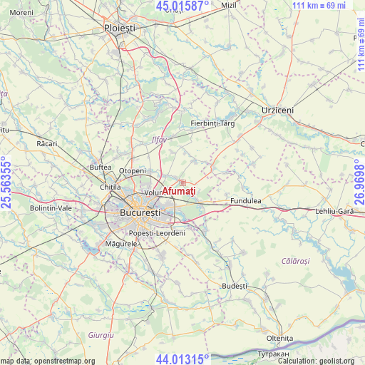
Afumaţi GPS coordinates[2]
44° 31' 0.012" North, 26° 16' 0.012" East
| Map corner | latitude | longitude |
|---|---|---|
| Upper-left | 45.01587°, | 25.56355° |
| Center: | 44.51667°, | 26.26667° |
| Lower-right: | 44.01315°, | 26.9698° |
| Map W x H: | 111.5×111.5 km | = 69.3×69.3mi |
| max Lat: | 48.23793° ⇑84.9% North |
| Afumaţi: | 44.51667° |
| min Lat: | ⇓15.1% South 43.65638° |
| min Long | Afumaţi | max Long |
| 20.31667° | 26.26667° | 29.65403° |
| W 68.1%⇐ | ⇒31.9% E |
Elevation
Elevation of Afumaţi is 79 m = 259 ft, and this is 175.9 m = 577 ft below average elevation for this country.
| Max E: |
1278 m = 4193 ft | 84.7% |
| Avg. | 254.9 m = 836 ft | |
| Afumaţi | 79 m = 259 ft | |
Min E: |
-2 m = -7 ft | 15.3% |
See also: Romania elevation on elevation.city.
Geographical zone
Afumaţi is located in North temperate zone (between Tropic of Cancer and the Arctic Circle). Distance of this Northern Tropic circle is 2343.9 km =1456.4 mi to South.| Distance of | km | miles | from Afumaţi |
|---|---|---|---|
| North Pole | 5057.3 | 3142.5 | to North |
| Arctic Circle | 2451.4 | 1523.2 | to North |
| Tropic Cancer | 2343.9 | 1456.4 | to South |
| Equator | 4949.8 | 3075.7 | to South |


Nearby cities:
15 places around Afumaţi: (largest is in red/bold)
• Brăneşti
9.1 km =5.7 mi,  144°
144°
• Cozieni
5.1 km =3.2 mi, 144°
• Dascălu
9.6 km =6 mi,  344°
344°
• Dobroeşti
9.9 km =6.2 mi,  221°
221°
• Găneasa
3.9 km =2.4 mi,  160°
160°
• Lilieci
9.6 km =6 mi,  67°
67°
• Moara Domnească
2.6 km =1.6 mi,  194°
194°
• Pantelimon
9.1 km =5.7 mi, 215°
• Pasărea
6.4 km =4 mi, 138°
• Petrăchioaia
8 km =5 mi,  27°
27°
• Piteasca
5.7 km =3.5 mi,  117°
117°
• Tunari
10 km =6.2 mi,  291°
291°
• Voluntari
8 km =5 mi,  248°
248°
• Ştefăneştii de Jos
5.6 km =3.5 mi, 289°
• Șindrilița
4.2 km =2.6 mi,  93°
93°
Sources, notices
• [Note1] Compared only with cities in Romania existing in our database
• [Src1] Map data: © OpenStreetMap contributors (CC-BY-SA)
• [Src2] Other city data from geonames.org with taken over terms of usage.
• [Src3] Geographical zone / Annual Mean Temperature by Robert A. Rohde @ Wikipedia
