Cozieni geodata
Cozieni (Ilfov) is a populated place; located in Romania in Europe/Bucharest (GMT+3) time zone. With population of 694 people, there are 5615 cities with bigger population in this country. Compared to other cities in Romania, 85.8% of cities are located further ↑North; 69% of cities are located further ←West and 86.5% of cities have higher elevation than Cozieni. Note1


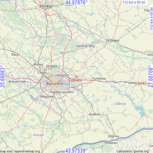
Cozieni GPS coordinates[2]
44° 28' 45.228" North, 26° 18' 14.22" East
| Map corner | latitude | longitude |
|---|---|---|
| Upper-left | 44.97876°, | 25.60083° |
| Center: | 44.47923°, | 26.30395° |
| Lower-right: | 43.97539°, | 27.00708° |
| Map W x H: | 111.6×111.6 km | = 69.3×69.3mi |
| max Lat: | 48.23793° ⇑85.8% North |
| Cozieni: | 44.47923° |
| min Lat: | ⇓14.2% South 43.65638° |
| min Long | Cozieni | max Long |
| 20.31667° | 26.30395° | 29.65403° |
| W 69%⇐ | ⇒31% E |
Elevation
Elevation of Cozieni is 73 m = 240 ft, and this is 181.9 m = 597 ft below average elevation for this country.
| Max E: |
1278 m = 4193 ft | 86.5% |
| Avg. | 254.9 m = 836 ft | |
| Cozieni | 73 m = 240 ft | |
Min E: |
-2 m = -7 ft | 13.5% |
See also: Romania elevation on elevation.city.
Geographical zone
Cozieni is located in North temperate zone (between Tropic of Cancer and the Arctic Circle). Distance of this Northern Tropic circle is 2339.7 km =1453.8 mi to South.| Distance of | km | miles | from Cozieni |
|---|---|---|---|
| North Pole | 5061.4 | 3145 | to North |
| Arctic Circle | 2455.5 | 1525.8 | to North |
| Tropic Cancer | 2339.7 | 1453.8 | to South |
| Equator | 4945.6 | 3073.1 | to South |


Nearby cities:
15 places around Cozieni: (largest is in red/bold)
• Afumaţi
5.1 km =3.2 mi,  324°
324°
• Brăneşti
4 km =2.5 mi,  144°
144°
• Bălăceanca
9.7 km =6 mi,  186°
186°
• Cernica
7.1 km =4.4 mi, 193°
• Căldăraru
8 km =5 mi,  203°
203°
• Dobroeşti
10.1 km =6.3 mi,  251°
251°
• Găneasa
1.7 km =1.1 mi,  285°
285°
• Islaz
6.9 km =4.3 mi,  106°
106°
• Lilieci
9.8 km =6.1 mi,  37°
37°
• Moara Domnească
4 km =2.5 mi, 293°
• Pantelimon
8.9 km =5.5 mi, 248°
• Pasărea
1.5 km =0.9 mi,  118°
118°
• Piteasca
2.6 km =1.6 mi,  52°
52°
• Tânganu
8.1 km =5 mi,  175°
175°
• Șindrilița
4.1 km =2.5 mi,  17°
17°
Sources, notices
• [Note1] Compared only with cities in Romania existing in our database
• [Src1] Map data: © OpenStreetMap contributors (CC-BY-SA)
• [Src2] Other city data from geonames.org with taken over terms of usage.
• [Src3] Geographical zone / Annual Mean Temperature by Robert A. Rohde @ Wikipedia
